Photos of Northern California (42)
There are (42) photos of the keyword, Northern California, available on our website. They are pictured below.The pictures are organized by category.
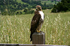
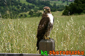
#382 — A scenic picture taken of a still hawk on a post in the hills of Palo Alto, California. This hawk is looking at me as I get closer and is deciding whether to fly away or not!
Hawk on Post
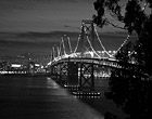
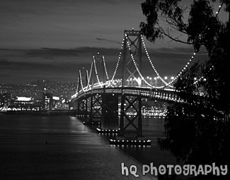
#305 — A scenic photo of the Bay Bridge in San Francisco, California taken in black and white and night. This photo is taken from across the San Francisco side looking at San Francisco. The Bay Bridge connects San Francisco to Oakland. The Bay Bridge opened to traffic on November 12, 1936. The total cost, including an electric railroad which has since been abandoned, was $79.5 million.
Black & White Bay Bridge at Night
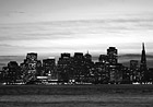
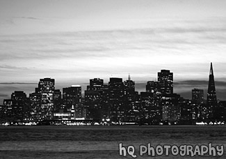
#304 — This is a scenic black and white photo of San Francisco, California taken from across the city at night. San Francisco is located in the bay area just north of San Jose.
Black & White San Francisco at Night
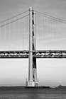
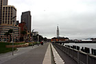
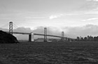
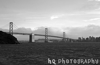
#347 — A scenic vertical picture taken of the Bay Bridge from San Francisco, California wharf area. This picture is in black and white and was taken on a sunny day.
Bay Bridge, San Francisco
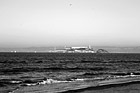
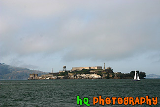
#303 — A scenic black and white photo of Alcatraz Island taken in San Francisco, California. By the late 1850's, the first military prisoners were being housed on the island, but it did not become a Federal prison until 1934. On March 21, 1963, Alcatraz closed after 29 years of operation. There were 36 different men involved in 14 escape attempts from prisoners while on the island. Officially, no one ever succeeded in escaping from Alcatraz, but to this day there are five prisoners listed as "missing and presumed drowned."
Black & White Alcatraz
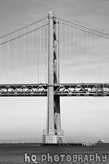
#342 — A scenic black and white picture taken of the San Francisco Bay Bridge from across the city of San Francisco on Treasure Island. In this picture you can see some fog rolling over the city in the background.
Black & White Bay Bridge from Treasure Island
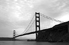
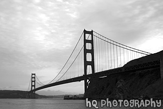
#345 — A scenic black and white picture taken of the Golden Gate Bridge in San Francisco, California on a cloudy day just before sunset. This photo was taken from the Marin County side of the bridge looking towards the Pacific Ocean showing the entire bridge in view.
Full Golden Gate Bridge View
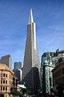
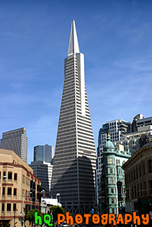
#387 — A scenic picture of the Transamerica Pyramid building located in the financial district of San Francisco, California. The Transamerica building was completed in 1972 and was the tallest building in the United States west of the Mississippi River from 1972-1974; surpassed by the Aon Center in Los Angeles. The Pyramid is no longer the company headquarters, but it serves as Transamerica's corporate logo and is strongly identified with the corporation. Today it is a world-class office tower and home to more than 50 high-profile firms employing about 1,500 people. It is also surrounded by 4 and 5 star hotels, restaurants, galleries, clubs and shopping, and the colorful neighborhoods of Jackson Square, Chinatown and North Beach.
Transamerica Pyramid
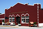
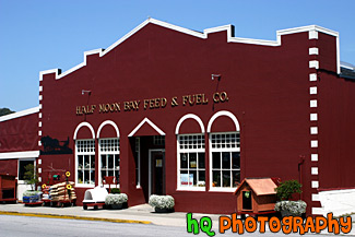
#615 — A scenic picture taken of the Half Moon Bay Feed & Fuel Co. which is located in downtown Half Moon Bay, California. This picture taken of the old fashion red building was taken on a sunny blue sky day. Half Moon Bay Feed & Fuel has been in continuous operation at its Main Street address since its founding in 1911.
Half Moon Bay Feed & Fuel Co.

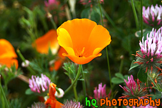
#377 — A close up picture of a traditional California orange poppy flower found all over California especially during the Spring.
California Orange Poppy
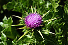
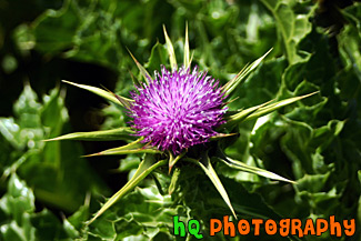
#370 — A close up image of a scenic wild purple flower found on a trail going towards Kehoe Beach in Marin County, California. These Winged Thistle wildflowers are common towards the beach in Northern California. Other common names for this flower could include: Winged Plumeless Thistle, and Italian Thistle.
Winged Thistle - Californian Purple Wildflower
#374 — A scenic picture taken on of California Falselupine (Thermopsis Macrophylla) past Pt. Reyes near the California coast and Pacific Ocean in Marin County. This picture was taken on a sunny spring day in April.
California Yellow Wildflowers
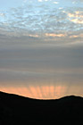
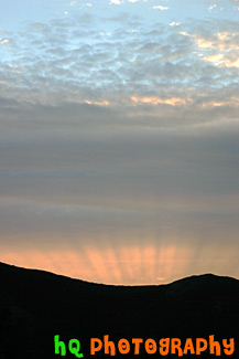
#372 — A scenic picture taken of a sunset over the hills of Mt. Tamalpais State Park near San Francisco. This picture was taken at the Golden Gate Bridge looking over towards the Pacific Ocean. You can see a silhouette of the hills in the foreground.
San Francisco Sunset
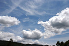
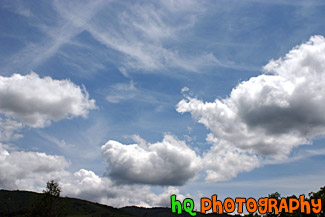
#379 — An interesting picture taken of some scenic puffy clouds and blue sky in the hills of the Santa Cruz Mountains in California.
Scenic Clouds & Blue Sky
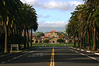
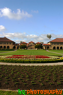
#380 — A scenic picture taken of Stanford University from Palm Drive looking at the "Oval" and "Stanford Mall." The building in the distance is Stanford Memorial Church which is located at the center of the campus. Palm Drive is a mile-long, palm tree-lined entrance to the Stanford campus. It connects Stanford with the neighboring town of Palo Alto. Bike and walking paths and an arboretum border Palm Drive, and the street culminates at the Oval, a lawn at the front of campus where students often study or play volleyball and Frisbee.
Stanford University from Palm Drive
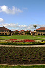
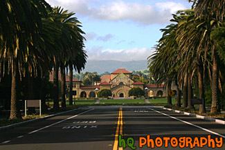
#315 — A scenic picture of Stanford University's main entrance taken from the oval. Stanford Memorial Church stands at the center of the campus, and was one of the earliest and is still among the most prominent interdenominational churches in the West. This photo was taken on a sunny blue sky day. The flowers in the front of the photo spell a cardinal "S" for Stanford.
Stanford University Main Entrance
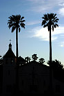
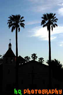
#351 — A scenic picture taken of the Mission Santa Clara de Asis located on the campus of Santa Clara University. This picture was taken as the sun was setting as you can see the changing sky color the silhouette of the Mission Church. This site in which the Mission is located is the fifth as floods, earthquakes, and fires forced the Santa Clara de Asis Mission to move five times. Each of the five mission sites are commemorated on the Santa Clara University campus of in the City of Santa Clara. The original mission was founded in 1777 near the current site of the San Jose airport. This first church was built in 1825 by the Spanish with no decoration. Ten years later figures of saints were painted on the church facade. Over the next 90 years the facade was remolded twice.
Silouette of Santa Clara Mission Church
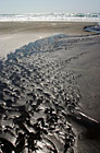
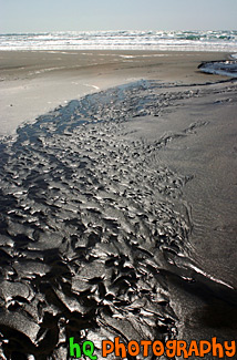
#366 — A scenic picture taken of the sand at Kehoe Beach, California which is located in Marin County. The sand is taking on an interesting form in this photo which makes it quite interesting.
Kehoe Beach Sand & Waves
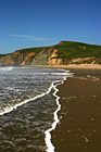
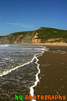
#369 — A scenic picture taken at Kehoe Beach in Marin County, California. In this picture you can see the white bubbles from the ocean wave coming to shore and making interesting lines towards the hill in the background.
Kehoe Beach Wave Lines
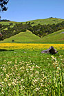
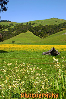
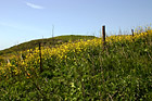
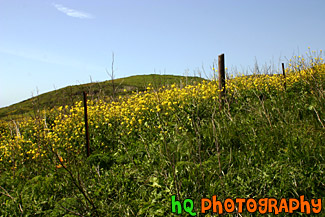
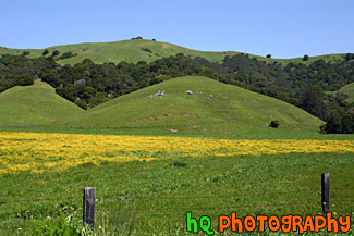
#367 — A scenic photo taken of a beautiful landscape scene with green grass, blue sky, close up wild flowers, and yellow flowers in Marin County, California. Marin County is just north of San Francisco. From 1850 to 1950 the population of Marin increased by 85,000 people. Twenty years later there were an additional 123,000 residents. Population growth has slowed since then and is now about 245,000. In 1972 the Golden Gate National Recreational Area was created which encompasses the Marin Headlands, Muir Woods and thousands of acres along the Pacific Coast.
Beautiful Marin County Landscape
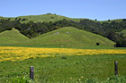
#364 — A scenic photo taken of a beautiful landscape scene with green grass, blue sky, and yellow flowers in Marin County, California. Marin County is just north of San Francisco. From 1850 to 1950 the population of Marin increased by 85,000 people. Twenty years later there were an additional 123,000 residents. Population growth has slowed since then and is now about 245,000. In 1972 the Golden Gate National Recreational Area was created which encompasses the Marin Headlands, Muir Woods and thousands of acres along the Pacific Coast.
Marin County Landscape of Hills
#350 — A scenic picture and contrast between a very green hill and partly cloudy blue skies. This picture was taken in San Jose of the very green hills (which are starting to turn brown) from the tremendous early 2005 rainfall.
Green Hill & Scenic Sky Scene
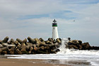
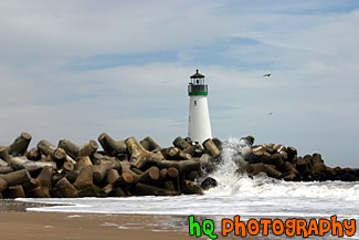
#386 — A scenic close up picture taken of the Walton Lighthouse in green on the beach at Santa Cruz, California. In this picture you can see the waves of the ocean crashing onto the rocks surrounding the lighthouse.
Santa Cruz Lighthouse (Walton)
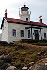
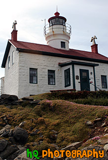
#686 — A scenic picture of Battery Point Lighthouse which is located in Crescent City, California. Battery Point Lighthouse was built in 1856 for a cost of $15,000. It was the 10th lighthouse built on the west coast. Crescent City is California's northernmost town, located on the flats behind Point George a few miles from the Oregon border. It has always been the main port for this remote corner of the state and has an important fishing fleet.
Battery Point Lighthouse
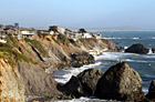
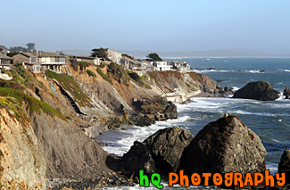
#490 — A scenic picture of houses along the coast of highway 1 in California located just north of Marin County and Point Reyes. Sea stacks can also be seen in the ocean.
California Coast Along Highway 1

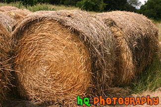
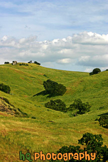
#381 — A scenic picture of a few big bundles of hay located atop a hill in Palo Alto, California.
Bundles of Hay
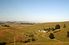
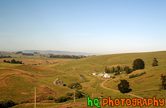
#907 — A scenic picture taken of farmlands located in Northern California on a beautiful blue sky sunny day.
Farmland in Northern California
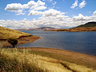
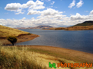
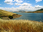
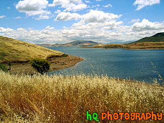
#45 — A scenic photo of a lake scene taken in Northern California on a partly cloudy day.
California Lake Scene
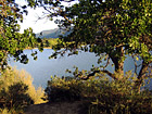
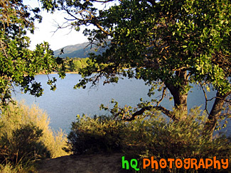
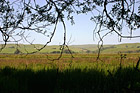
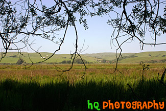
#46 — A photo of a lake looking through some trees and branches. This photo was taken at a campground in Northern California.
Lake & Scenic Trees
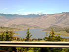
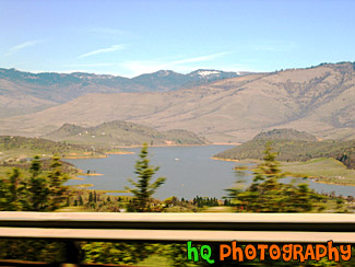
#67 — A view of Lake Shasta, California while driving North on I5. You can tell this photo was taken while the car was moving because the trees in the foreground are blurry but the lake itself is in focus.
Lake Shasta from I5
#44 — A landscape scene in Northern California near Gilroy of a lake and puffy clouds on a sunny day.
Landscape Lake Scene
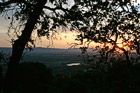
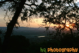
#373 — A scenic picture taken a top a hill in East San Jose overlooking the entire city and bay area. This picture shows a scenic house amongst the view of the city during a spectacular sunset.
East San Jose Hill Sunset
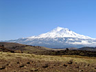
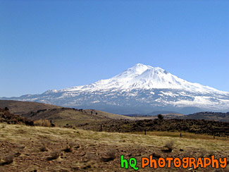
#66 — Mt. Shasta located in Northern California on the Cascade Range. Mount Shasta stands 14,162 feet high. Avalanche Gulch route is one of the most popular and climbed routes in the United States with an estimated 15,000 climbers that attempt the summit annually. With 17 established routes, each with variations, there is climbing available for beginners as well as advanced mountaineers. The terrain consists of loose volcanic talus, rock & ice, and glaciers. This photo was taken on a sunny day.
Mount Shasta
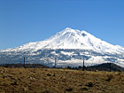
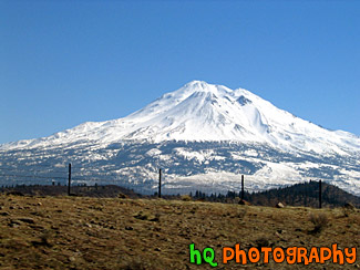
#65 — Mt. Shasta located in Northern California on the Cascade Range. Mount Shasta stands 14,162 feet high. Avalanche Gulch route is one of the most popular and climbed routes in the United States with an estimated 15,000 climbers that attempt the summit annually. With 17 established routes, each with variations, there is climbing available for beginners as well as advanced mountaineers. The terrain consists of loose volcanic talus, rock & ice, and glaciers.
Mt. Shasta
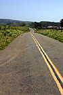
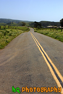
#371 — A photo of a scenic road taken in the farm lands of Marin County out toward the coast of the Pacific Ocean. This picture was taken out past Pt. Reyes, California.
Marin County Farm Road
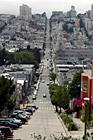
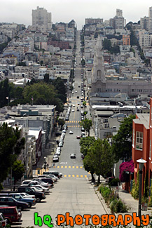
#384 — A scenic picture taken of a road in San Francisco, California from one end of the city going down a hill and back up another to the other end of the city. From this picture you can also see the scenic San Francisco buildings and houses.
San Francisco Road
#365 — A scenic picture taken in Point Reyes, California in Marin County. Point Reyes is home to many native land mammals which number about 37 species. Marine mammals also add to this total by another 12 species. The biological diversity stems from a favorable location in the middle of California and the natural occurrence of many distinct habitats which makes Point Reyes a fun place to visit.
Point Reyes Landscape Scene
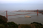
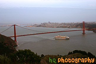
#363 — A scenic picture taken of the entire Golden Gate Bridge in San Francisco with a view of the city behind and a big cruise ship leaving the bay area underneath. This picture was taken at dusk from the top of Hawk Hill which is located just north of San Francisco in the Marin Headlands.
Cruise Ship Under Golden Gate Bridge
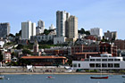
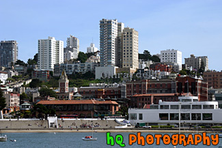
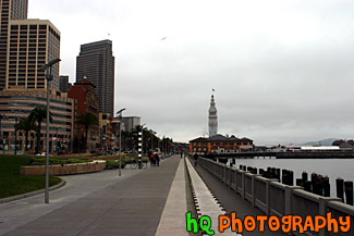
#348 — A picture taken of Ghirardelli Square in San Francisco, California. This picture was taken out on a dock looking in towards the shore and the square. Ghirardelli Square is a historic San Francisco destination, offering shopping San Francisco style, waterfront dining near Fisherman's Wharf, art galleries, family events, walking tours and more. Today the original 1860 cast iron chocolate grinder from France is located on the lower plaza, and other chocolate-making equipment is still operating on a small scale in the Ghirardelli Chocolate Manufacture.
Ghirardelli Square in San Francisco
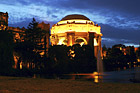
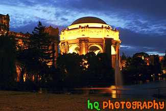
#368 — A scenic picture taken of the Palace of Fine Arts building at night in downtown San Francisco. With this picture taken at night you can see the palace lit up and the water fountain streaming. The task of creating a Palace of Fine Arts for the 1915 Panama-Pacific International Exposition fell to the architect Bernard R. Maybeck, then fifty years old and known for his innovative ideas. Setting to work on this new project, he chose as his theme a Roman ruin, mutilated and overgrown, in the mood of a Piranesi engraving. The Palace of Fine Arts was meant to give delight by its exterior beauty, but its purpose was also to offer all visitors a stimulating experience within doors
Palace of Fine Arts Exploratorium at Night
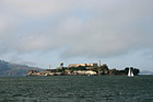
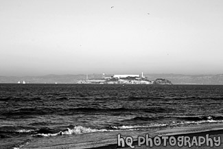
#491 — A scenic picture taken of Alcatraz Island located in San Francisco, California. Alcatraz Island served as a military fortification in the 1850s, an incarceration facility for Spanish-American War prisoners, and a federal maximum-security prison from 1934 to 1963. Alcatraz Island is now one of Golden Gate National Recreation Area's most popular destinations, offering a close-up look at a historic and infamous federal prison long off-limits to the public. Alcatraz Island is also commonly known as the "Rock."
Alcatraz Island & Prison