Photos of Cloudy Sky (72)
There are (72) photos of the keyword, Cloudy Sky, available on our website. They are pictured below.The pictures are organized by category.

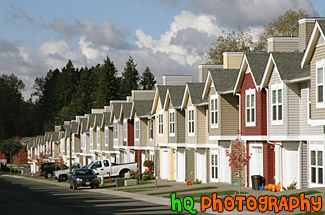
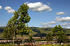
#1450 — A scenic picture taken of a line of townhouses in a row on a partly cloudy day. The colors change from one condo to the next.
Line of Townhouses
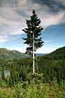
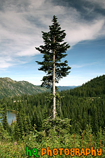
#654 — A scenic picture taken of a single evergreen tree on the hill above a lake in the Louise Lake in the Mount Rainier National Park. You can see part of the Louise Lake to the left and the hills in the national park in the background.
Evergreen Tree in Forest
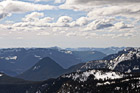
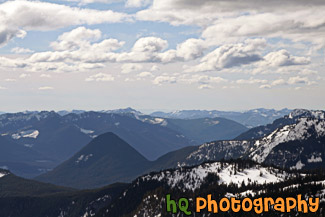
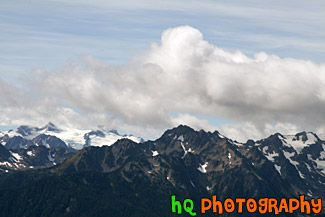
#1504 — A scenic picture overlooking the snow-capped hills of Mt. Rainier National Park. This picture was taken from a snowshoeing trail at Paradise on a partly cloudy day.
Snow Capped Hills from Paradise
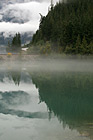
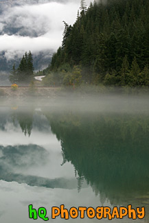
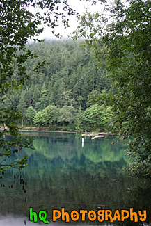
#1728 — A scenic vertical picture taken of the clouds and trees reflection in Diablo Lake which is located in the North Cascades National Park in Washington State.
Clouds & Trees Reflection in Diablo Lake
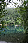
#1669 — A scenic vertical picture taken of tree reflections in Lake Cresent which is located near Port Angeles in the Olympic National Park in Washington state. This photo was taken on the west side of the lake near the Fairholm campground.
Early Morning Lake Reflections
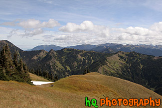
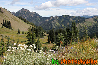
#1779 — A scenic picture taken of the hills of the Olympic Mountains during a nice late summer day. In this picture you can see two people in distance sitting on the ground enjoying their surroundings. This photo was taken near Hurricane Ridge.
Olympic Mountain Hills & Scenic Sky
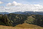
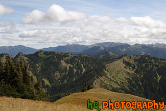
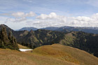
#2010 — A scenic picture taken of the Olympic Mountain Ranges on a partly cloudy sunny day. This photo was taken near Hurricane Ridge.
Olympic Mountain Ranges
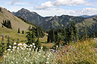
#1674 — A scenic picture taken of the Olympic Mountain landscapes located near Hurricane Ridge. In this photo you can see wildflowers, evergreen trees, and a partly cloudy sky.
Olympic Mountains Fields & Wildflowers
#1675 — A close up picture taken of the Olympic Mountains from Hurricane Ridge. Partly cloudy and blue skies are seen above.
Olympic Mountains Up Close
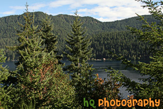
#1693 — A scenic picture taken of trees and mountains located around Lake Cresent in the Olympic National Park with partly cloudy skies.
Trees & Mountains Around Lake Cresent

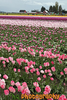
#2293 — A scenic vertical photo taken of the colorful tulip fields in Skagit Valley at the tulip festival. Cloudy sky is seen above and people are in the distance. Purple and pink flowers dominate this field.
Tulip Field in Skagit Valley

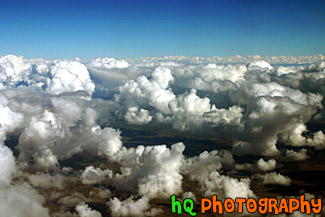
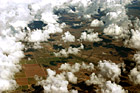
#25 — A scenic photo of puffy clouds taken from an airplane flying into Phoenix, Arizona. This picture was taken looking out of the airplane window. The clouds were especially puffy on this day and was a site to see.
Puffy Clouds Aerial View
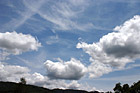

#379 — An interesting picture taken of some scenic puffy clouds and blue sky in the hills of the Santa Cruz Mountains in California.
Scenic Clouds & Blue Sky


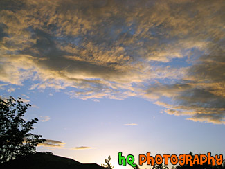
#1749 — A scenic picture taken of a blue, purple, and orange sunset on a partly cloudy night.
Blue, Purple, & Orange Sunset


#31 — This is a picture of the bright blue sky with a few clouds in the skies of San Jose, California.
Bright Blue Sky and Clouds
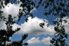
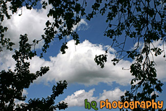
#361 — A scenic picture taken of some puffy white clouds, blue sky, and tree branches. This picture was taken during a break in rain clouds in the bay area by the Santa Cruz mountains, California.
Clouds, Blue Sky, & Tree Branches
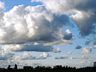
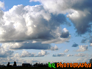
#28 — A scenic picture taken of the sky out in the country. For some reason Washington State gets a lot of "puffy" clouds that can seen on partly cloudy days. Here is a photo of some puffy clouds scattered throughout the blue sky.
Puffy Clouds Over Farm
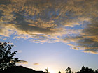
#26 — A pretty sunset while darkness is starting to set in. This photo was taken in the foothills of the Cascade Mountains in Washington State. Many sunsets like this one can be captured year round in this state.
Sunset & Silhouette
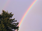
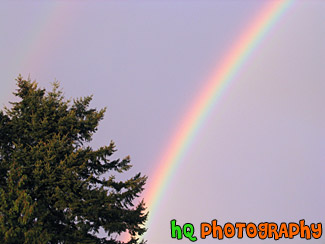
#52 — A scenic picture taken of two rainbows. If you look carefully above the darker rainbow you will find another faint rainbow. The faint rainbow is located above the really bright rainbow. This photo was taken during a rain storm in Enumclaw, Washington after the sun was trying to break through the heavy clouds.
Two Rainbows
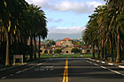
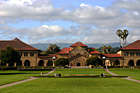
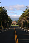
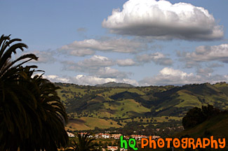
#380 — A scenic picture taken of Stanford University from Palm Drive looking at the "Oval" and "Stanford Mall." The building in the distance is Stanford Memorial Church which is located at the center of the campus. Palm Drive is a mile-long, palm tree-lined entrance to the Stanford campus. It connects Stanford with the neighboring town of Palo Alto. Bike and walking paths and an arboretum border Palm Drive, and the street culminates at the Oval, a lawn at the front of campus where students often study or play volleyball and Frisbee.
Stanford University from Palm Drive
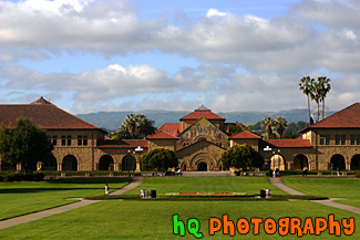
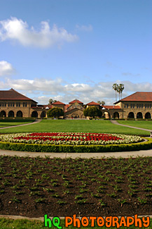
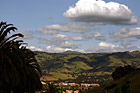
#358 — A scenic picture taken at the "Oval" at Stanford University in Palo Alto, California. The Oval is located down Palm Drive on the Stanford University campus. In this picture you can see the Stanford Memorial Church as well as the scenic green hills of Palo Alto behind the buildings in the distance.
Oval at Stanford University
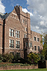
#1803 — A scenic vertical picture taken of a portion of Mary Gates Hall located on campus at the University of Washington in Seattle.
Portion of Mary Gates Hall at UW
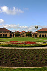
#315 — A scenic picture of Stanford University's main entrance taken from the oval. Stanford Memorial Church stands at the center of the campus, and was one of the earliest and is still among the most prominent interdenominational churches in the West. This photo was taken on a sunny blue sky day. The flowers in the front of the photo spell a cardinal "S" for Stanford.
Stanford University Main Entrance
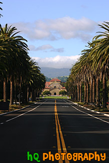
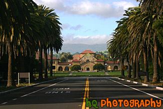
#1244 — A scenic vertical picture taken of Stanford University's main entrance on Palm Drive. This road is lined with palm trees all the way down to the university heading towards the Memorial Church seen in the background.
Stanford University Palm Drive Entrance
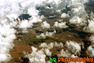
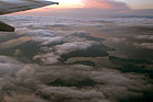
#115 — This photo is a scenic aerial shot taken over the land around Phoenix, Arizona as the plane was getting ready to land at the airport. In this photo you can see the scenic land through all the puffy clouds.
Aerial Arizona & Clouds
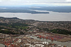
#1883 — A scenic aerial picture taken of the Puget Sound area in Washington State. This picture was taken on an overcast, cloudy day.
Aerial View of Puget Sound
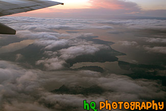
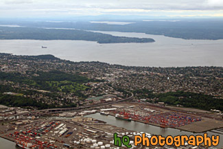
#1088 — A scenic aerial picture taken during a sunset looking down at the Puget Sound in Washington State from an airplane which has just taken off from the Seatte/Tacoma International Airport. Through the clouds you can see the sound and islands of Washington State.
Sky Sunset & Puget Sound
#318 — Scenic picture of the green hills of San Jose during February of 2005. This picture was taken at a spot on the east San Jose hills just north of the Evergreen area. The hills are especially green right now in February because of the tremendous rainfall the bay area has experienced this season. The rain has made for a some beautiful green hills surrounding San Jose, California.
Green Hills of San Jose
#950 — A scenic picture taken of a landscape scene in the East San Jose area near Evergreen Village. This picture was taken on a beautiful day with scattered clouds and blue sky. You can see the green hills from much rain this year in the background with shadows from the clouds over them.
Blue Sky, Green Hills, & Trees in San Jose
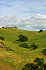
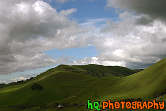
#350 — A scenic picture and contrast between a very green hill and partly cloudy blue skies. This picture was taken in San Jose of the very green hills (which are starting to turn brown) from the tremendous early 2005 rainfall.
Green Hill & Scenic Sky Scene
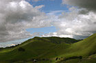
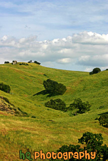
#473 — A scenic picture taken of some green hills with the shadows of the clouds on the hills from the partly cloudy sky. This picture was taken in South/East San Jose near the Silver Creek Valley area.
Green Hills & Partly Cloudy Sky
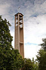
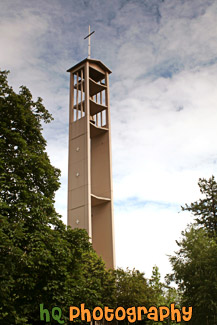
#1078 — A scenic picture taken of the cross on top of the Trinity Lutheran Church building located at Pacific Lutheran University in Tacoma, Washington.
Cross at Trinity Lutheran Church, PLU
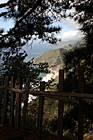
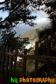
#1774 — A scenic vertical picture taken along the Highway 1 coast in California. This picture was taken looking down at the Pacific Ocean through a fence and trees on a hill. Hills along the coast are seen in the background.
Highway 1 Coast
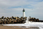
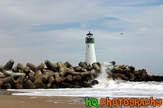
#386 — A scenic close up picture taken of the Walton Lighthouse in green on the beach at Santa Cruz, California. In this picture you can see the waves of the ocean crashing onto the rocks surrounding the lighthouse.
Santa Cruz Lighthouse (Walton)
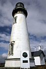
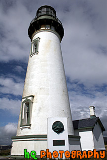
#583 — A close up scenic picture taken of the Yaquina Head Lighthouse which is located along the coast of Oregon State and the Pacific Ocean. This picture was taken on a partly cloudy day. This historic lighthouse is 93 (28 m) feet tall and was built in 1872-73. Its light towers are 162 feet (49 m) above the sea, and can be seen about 19 miles (32 km) out to sea. This lighhouse was automated in 1966 in which the light flashes two seconds on, two off, two on, 14 off, then repeats. Each light has its own pattern so it will not be confused with other lights.
Yaquina Head Lighthouse
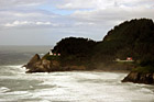
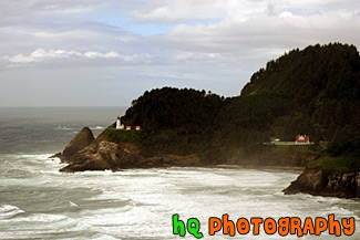
#457 — A scenic picture taken of the Heceta Head Lighhouse located on the Oregon coast, just after the famous Sea Lion Caves. The lighthouse is a working lighthouse and has a height of 205 feet above the Pacific Ocean. To the right of the lighthouse is the Keeper's house. There are some spectacular view seen from the front porch of the Keeper's house. Whales sometimes stop by at high tide and use the shallow rocks to scratch the barnacles off their sides. Up by the light house is some of the best whale watching one can do from dry land. Heceta Head Lighthouse is one of the most visited lighthouses in the United States drawing thousands of visitors each year to sense its history, romantic aura, and spectacular view. The Heceta (pronounced he-SEE-tuh) Head Lighthouse, constructed in 1874, was named for Spanish explorer Don Bruno De Heceta. Its light is the most powerful beacon on the Oregon coast, visible 21 miles out to sea.
Heceta Head Lighthouse, Oregon Coast
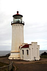
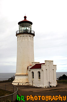
#995 — A scenic picture taken of the North Head Lighthouse located along the coast in Washington State. This lighthouse has a red tip. The North Head is the windiest lighthouse area on the West Coast and the third windiest in the nation. Winds of 120 miles per hour have been recorded at the site.
North Head Lighthouse in Washington
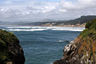
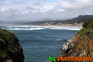
#668 — A scenic picture of the Oregon coast and Pacific Ocean looking to the North from Yaquina Head Lighthouse which is near Newport and Depoe Bay. In this picture the sky is thick with low puffy clouds that are about to be burned off.
Oregon Coast
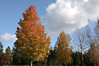
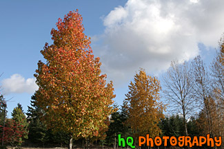
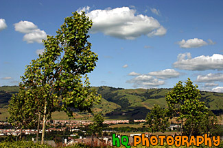
#1374 — A scenic picture taken of colorful trees changing color during the autumn season with a partly cloudy sky in the background.
Fall Trees & Blue Sky
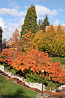
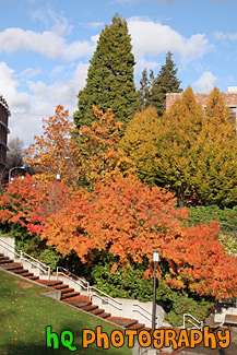
#1783 — A scenic picture taken of the fall colors seen on trees located on campus at the University of Washington. In this picture you can see the colors red, orange, green, yellow, and blue (in the sky). Leaves are also seen on the ground below the trees.
Scenic Colors of Fall
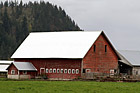
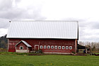
#1003 — A scenic picture taken at an agle of a red barn located on a farm in Enumclaw, Washington. This picture was taken on a cloudy day and you can see the right side of Mt. Peak in the background.
Red Barn on Farm
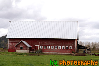
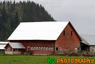
#1004 — A scenic picture taken of the side of a red barn located on a farm in Enumclaw, Washington. This photograph was taken on a cloudy day.
Side of Red Barn
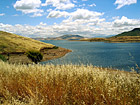
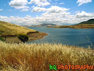
#44 — A landscape scene in Northern California near Gilroy of a lake and puffy clouds on a sunny day.
Landscape Lake Scene
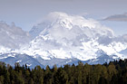
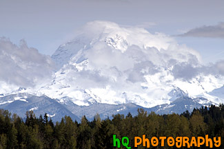
#1028 — A scenic picture taken of Mount Rainier on a partly cloudy day as you can see the blue sky above the mountain and clouds hovering around it. This picture was taken looking toward the north side of Mount Rainier from Bonney Lake, Washington.
Clouds, Blue Sky & Mt. Rainier
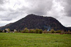
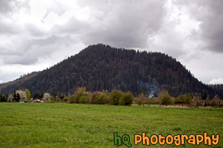
#1008 — A scenic picture taken of the local small mountain in which people of the area hike up to receive and excellent workout. This picture was taken on a cloudy day in Enumclaw, Washington. A green grass field is seen in the foreground and a little bit of smoke is seen just before the mountain.
Mt. Peak, Enumclaw
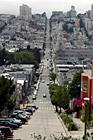
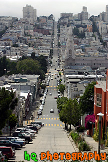
#384 — A scenic picture taken of a road in San Francisco, California from one end of the city going down a hill and back up another to the other end of the city. From this picture you can also see the scenic San Francisco buildings and houses.
San Francisco Road
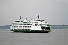
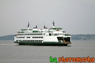
#1543 — A scenic picture taken of a Mukilteo, Washington ferry boat on a cloudy day.
Ferry Boat & Cloudy Day
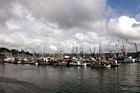
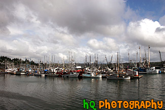
#585 — A scenic picture taken of a bunch of sailboats located in the water along the coast at Newport, Oregon. In this picture you can see the partly cloudy skies with the big puffy clouds. Newport was etablished in 1882 and is now a bustling coastal community of over 9,000 people. It's heart is along a working waterfront on Yaquina Bay where fishing fleets and fresh seafood markets coexist with galleries, gift shops, restaurants and family attractions.
Sailboats of Newport, Oregon
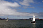
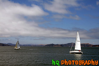
#1848 — A scenic picture taken of two sailboats sailing in the bay area waters of San Francisco. This picture was taken on a partly cloudy sky with blue sky seen.
Two Sailboats in San Francisco Bay
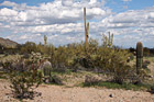
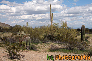
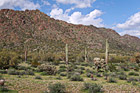
#2281 — A scenic picture taken of an Arizona landscape scene with lots of cacti and puffy clouds in the sky. This photo was taken in the desert at San Tan Mountain Regional Park.
Arizona Cacti & Clouds
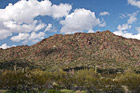
#2322 — A scenic picture taken of an Arizona landscape located at the San Tan Mountain Regional Park. The mountain can been seen in the background behind some cacti trees. Partly cloudy sky is above.
Arizona Landscape
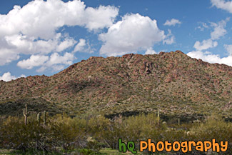
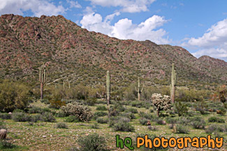
#2283 — A scenic picture taken of the Arizona desert landscape seen at San Tan Mountain Regional Park. You can see some puffy clouds above the mountain and some cacti trees in the foreground.
Arizona Landscape at San Tan Mountain

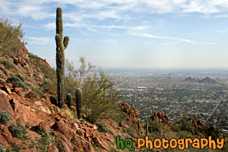
#2272 — A scenic picture taken of a pretty view from the hike on Camelback Mountain near Phoenix, Arizona. You can see a cactus tree in the foreground.
Cactus & Camelback Mountain View
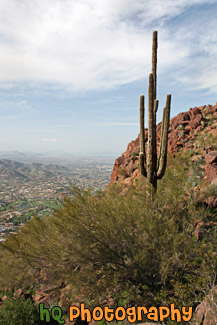
#2279 — A scenic vertical picture taken of a Camelback Mountain view and a cactus tree in the foreground in Arizona State.
Camelback Mountain & Cactus
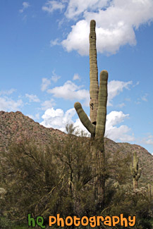
#2323 — A scenic vertical picture taken of a tall Saguaro cactus tree located in the San Tan Mountain Regional Park in Arizona. The photo was taken on a partly cloudy day.
Saguaro Cactus
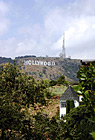
#1771 — A scenic vertical picture taken of the Hollywood Sign on the hill in Los Angeles, California. Partly cloudy, blue sky is seen above.
Hollywood Sign
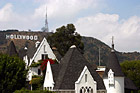
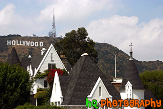
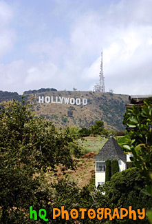
#1394 — A scenic picture taken of a white house with the famous Hollywood sign seen in the background on a hill.
Hollywood Sign & White House
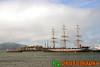
#32 — A scenic picture taken of the big Balclutha boat sitting in front of Alcatraz Island on this beautiful day in San Francisco. Alcatraz is a popular tourist attraction in this area as it was once used as a prison facility to hold inmates.
Alcatraz & Balclutha Boat
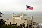
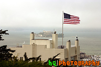
#383 — A scenic picture taken of Alactraz Island and a flag in the foreground in San Francisco. This picture was taken from the Coit Tower.
Alcatraz & Flag
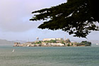
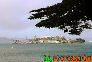
#566 — A scenic picture taken of Alcatraz Island with a tree branch in view from atop a hill in San Francisco, California.
Alcatraz with Tree Branch
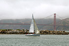
#1569 — A scenic picture taken of a sail boat floating off shore in front of the Golden Gate Bridge seen in the bay in San Francisco, California. Fog is seen over the hill just beyond the bridge.
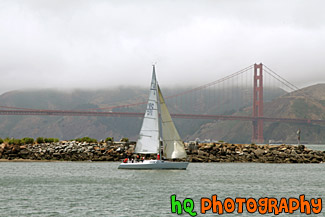
Sail Boat & Golden Gate Bridge
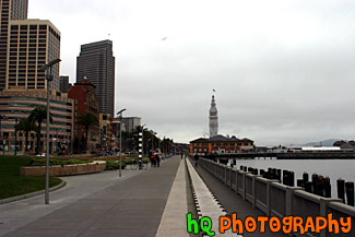
#340 — A scenic picture taken of San Francisco, California looking towards the piers and wharf of San Francisco. This part of San Francisco is a popular tourist spot and you can see many people walking along the wharf year round.
San Francisco Piers & Wharf
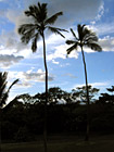
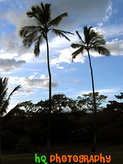
#169 — A scenic silhouette of two palm trees located in Maui, Hawaii with a beautiful sky behind them as the sun is getting ready to set on this beautiful island.
Two Palm Trees of Maui
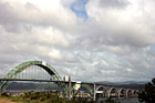
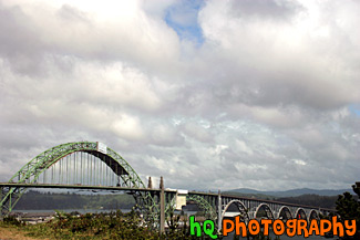
#777 — A scenic picture taken of the Yaquina Bay Bridge located near the Yaquina Head Lighthouse along the coast in Oregon State. This picture was taken on a day with interesting puffy clouds which filled the sky. This bridge is composed of five concrete support decks that lead to a dramatic, high-soaring steel arch. Each end of the structure has a pedestrian plaza with winding stairways that lead to lookout spots. Newport today is a bustling coastal community of over 9,000. It's heart is along a working waterfront on Yaquina Bay where fishing fleets and fresh seafood markets coexist with galleries, gift shops, restaurants and family attractions. Across the bay is the acclaimed Oregon Coast Aquarium and the Hatfield Marine Science Center. Historic Nye Beach, 2 lighthouses, museums and wide sandy beaches provide activity for people of all ages.
Newport, Oregon - Yaquina Bay Bridge

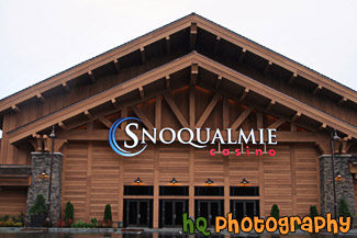
#2148 — A close up photo taken of part of the new Snoqualmie Casino building located in Snoqualmie, Washington State.
Snoqualmie Casino
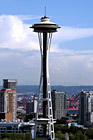
#412 — A scenic picture taken of the Seattle Space Needle in downtown Seattle, Washington. This photo was taken from Queen Anne Hill overlooking the city. The 605 foot (184 meter) Space Needle was designed by Edward E. Carlson for the 1962 World's Fair in Seattle. The futuristic structure has become a symbol for the city, and is home to festive events such as the annual New Year's Eve fireworks display.
Seattle Space Needle, Washington
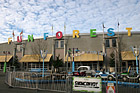
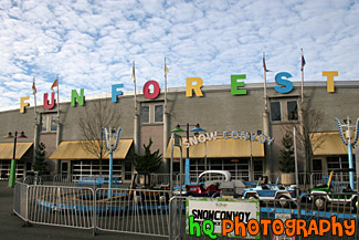
#1929 — A scenic picture taken of the Fun Forest located at the Seattle Center in downtown Seattle. Fun Forest Amusement Park, with games and 19 rides for kids and thrill seekers alike, is a playground for all ages. The Fun Forest has a roller coaster, carousel, and prize winning games. The Fun Forest also features the Entertainment Pavilion, open daily year-round with three rides, laser tag, mini-golf, prize games and a full video arcade.
Seattle Center Fun Forest
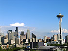
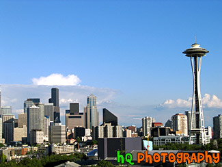
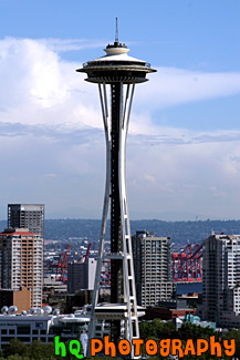
#124 — A scenic view of the Space Needle and Seattle, Washington from a hill near Seattle. Blue sky is seen above and the tall buildings of Seattle are to the left.
Space Needle & Seattle
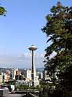
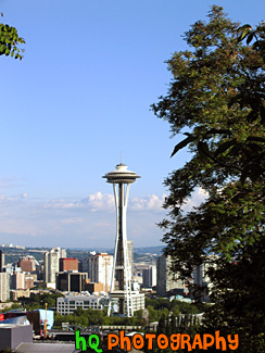
#152 — A view of the Space Needle from a hill near Seattle. The 605 foot (184 meter) Space Needle was designed by Edward E. Carlson for the 1962 World's Fair in Seattle. The futuristic structure has become a symbol for the city, and is home to festive events such as the annual New Year's Eve fireworks display. The Space Needle was completed in December 1961, and officially opened four months later on the first day of the World's Fair, April 21, 1962.
Tree & Space Needle
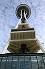
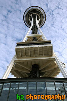
#844 — An interesting picture taken of the Seattle Space Needle from practically standing underneath it. This picture was taken with a scenic patchy cloudy and sunny sky.
Under the Space Needle
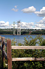
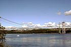
#1086 — A scenic picture taken of a wooden fence in the foreground of the "double" Narrows Bridge. Being built next to the old Narrows Bridge built in 1950 is the new bridge which is nearly 80 percent complete. The new bridge opens to traffic in summer 2007, but renovations on the 1950 bridge go on for another 11 months after that. In summer 2008, when the new and existing bridges open in their final form, the 1950 span will take drivers westbound on two general purpose lanes and one carpool lane. The new bridge will carry eastbound traffic on two general purpose lanes, one carpool lane and a fourth "drop" lane.
Narrows Bridge Construction & Fence
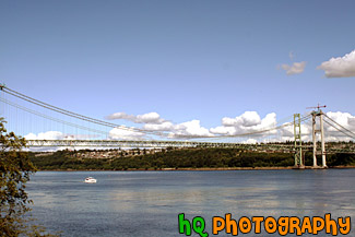
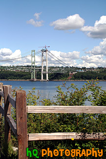
#1087 — A scenic picture taken of the Narrows Bridge project in process as the new bridge is being built right beside the old bridge of 1950. The new bridge opens to traffic in summer 2007, but renovations on the 1950 bridge go on for another 11 months after that. In summer 2008, when the new and existing bridges open in their final form, the 1950 span will take drivers westbound on two general purpose lanes and one carpool lane. The new bridge will carry eastbound traffic on two general purpose lanes, one carpool lane and a fourth "drop" lane.
Narrows Bridge Project, Tacoma
