Photos of Shore (63)
There are (63) photos of the keyword, Shore, available on our website. They are pictured below.The pictures are organized by category.
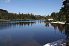
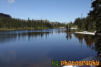
#1713 — A scenic picture taken of Reflection Lake which is located in the Mt. Rainier National Park, Washington. This picture was taken on a sunny day with blue sky seen above and some reflections of the trees in the lake. Snow is also still seen on the shores of the lake.
Reflection Lake in Mt. Rainier National Park
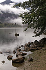
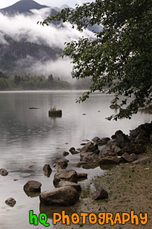
#1831 — A scenic vertical picture taken of rocks and a tree along the shore at Diablo Lake which is located in the North Cascades National Park in Washington State. You can see mountain hills and fog in the background.
Rocks & Tree Along Diablo Lake
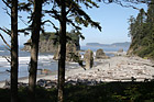
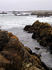
#1761 — A scenic vertical picture taken of the beach on rocks along the shore at Ruby Beach which is part of the Olympic National Park located in Washington State.
Beach and Rocks at Ruby Beach
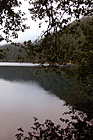
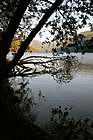
#1790 — A scenic vertical picture taken of a hill reflection and tree branches reflecting into Cresent Lake which is located in the Olympic National Park in Washington State.
Hill Reflection & Tree Branches
#1682 — A scenic picture looking out at Ruby Beach from the lookout point at the top of the hill. This picture was taken on a blue sky, sunny day with lots of people out walking along the beach and enjoying the sunshine.
Looking Out at Ruby Beach
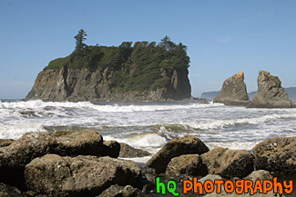
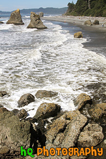
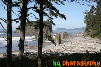
#1708 — A scenic picture taken of Ruby Beach and the sea stacks seen in the Pacific Ocean along the shore. Ruby Beach is located in the Olympic National Park in Washington State.
Ruby Beach Sea Stacks
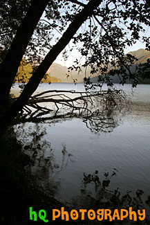
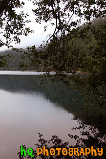
#1789 — A scenic vertical picture taken of trees, branches, and silhouettes along the shore of Cresent Lake which is located in the Olympic National Park. This photo was taken on a sunny day.
Trees & Silhouettes on Shore at Cresent Lake
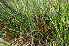
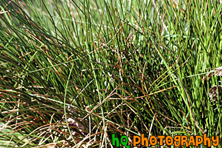
#1050 — A close up picture taken of thick, tall, green grass located along the shore of Lake Tapps in Bonney Lake, Washington.
Thick Grass Close Up
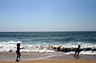
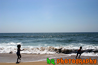
#755 — A photo taken of two kids having fun on the beach running away from the ocean waves. This picture was taken on the beach in Half Moon Bay, California on a sunny Spring afternoon.
Kids Running Away from Ocean Waves
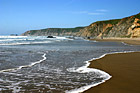
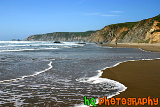
#1395 — A scenic picture taken of the Kehoe Beach located near Marin County, California along the coast of the Pacific Ocean. The waves are washing up onto the shore of this big beach.
Kehoe Beach, California
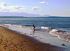
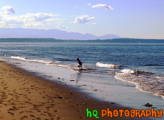
#117 — A photo of a kid running away from the waves at Alki Beach in Seattle, Washington. Alki Beach is located on a beach across the city of Seattle. There are some nice views of the city from this beach.
Kid & Beach
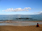
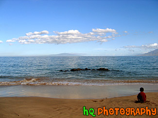
#186 — A picture of a child playing in the sand on the island and shorline of Maui, Hawaii.
Kid Playing in Sand
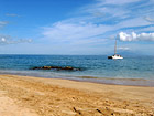
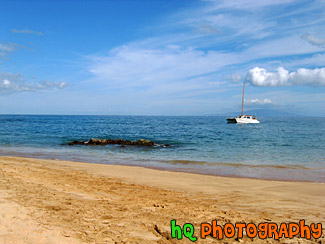
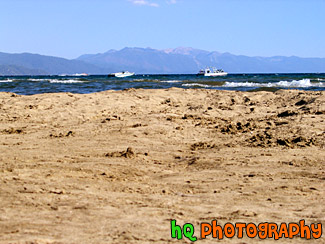
#176 — A photo of the Pacific Ocean off the coast of Maui, Hawaii. In this photo you can see a very scenic shot of the Pacific Ocean, the beach, and a small boat parked in the ocean. The ocean is pretty calm in this photo.
Pacific Ocean & Boat, Maui
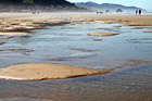
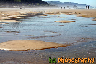
#2022 — A scenic picture of some water pockets on the beach at Cannon Beach, Oregon. In the distance you can see people walking on the beach and hills in the background.
Beach Water Pockets
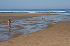
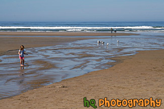
#2003 — A scenic picture taken of a popular beach in Oregon, Cannon Beach. In this photo you can see people walking along the ocean, seagulls on the sand, and a girl playing on the beach.
Beach, Seagulls & Child Playing
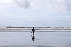
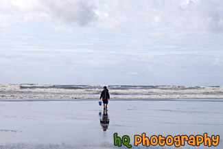
#2097 — A scenic picture taken of a kid walking on a beach with a bucket. This was taken at Ocean Shores along the coast in Washington State. You can see the Pacific Ocean waves in the background.
Kid with Bucket on Beach
#2025 — A scenic picture of a little boy on the beach playing in the sand with his sand bucket and shovel. This photo was taken on Cannon Beach in Oregon State with the Pacific Ocean seen in the background.
Little Boy on Beach
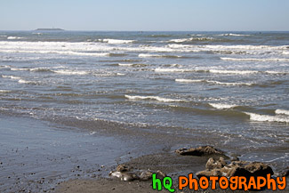
#2019 — A scenic picture taken of the Pacific Ocean waves located along the shore at Cannon Beach, Oregon.
Ocean Waves Along Beach
#128 — A picture taken of the beach of the Pacific Ocean off the coast of Pebble Beach, California. This picture was taken on the 17 mile scenic route along Highway 1.
Pebble Beach 17 Mile Scenic Route
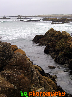
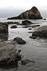
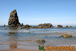
#2108 — A scenic vertical picture taken of some big rocks and seaweed located along the shore of the Pacific Ocean in California at Muir Beach.
Rocks & Seaweed on Shore
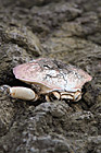
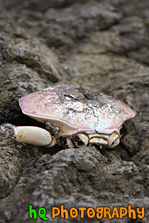
#1810 — A scenic vertical picture taken of a sea life creature sitting on rocks at Muir Beach located in Northern California near San Francisco.
Sea Life on Rocks
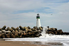
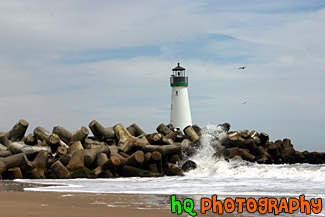
#386 — A scenic close up picture taken of the Walton Lighthouse in green on the beach at Santa Cruz, California. In this picture you can see the waves of the ocean crashing onto the rocks surrounding the lighthouse.
Santa Cruz Lighthouse (Walton)
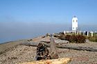
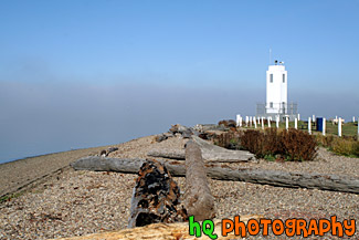
#1139 — A scenic picture taken of the Brown's Point lighthouse with fog in the distance and the shore in the foreground. Browns Point is situated on the eastern side of the entrance to Commencement Bay, which leads from Puget Sound to the port of Tacoma. The Brown's Point lighthouse is located in Browns Point Lighthouse Park lies on the tip of historic Browns Point, and provides the community waterfront access, enticing beachcombers year round and sunbathers and picnickers during the summer.
Brown's Point Lighthouse and Shore
#296 — This is a scenic photo taken along the coast of highway 1 in California. Highway 1 is a highway that runs along the coast of the Pacific Ocean with some breathtaking views.
Coast Along Highway 1, California
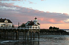
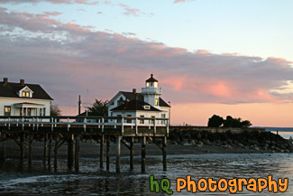
#2297 — A scenic picture taken of the Mukilteo Lighthouse during sunset in Washington State. You can see the sky colors start to change to pink/purple with blue sky and clouds in the photo.
Mukilteo Lighthouse at Sunset
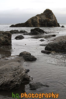
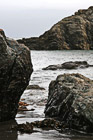
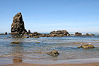
#2109 — A scenic vertical picture taken of some big ocean rocks located along the shore at Muir Beach in California.
Ocean Rocks Along Beach
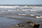
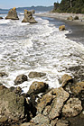
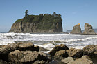
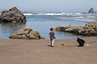
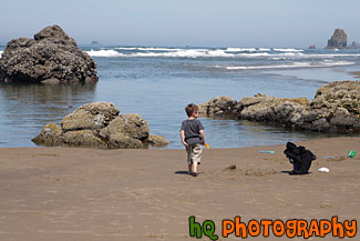
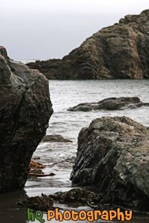
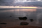
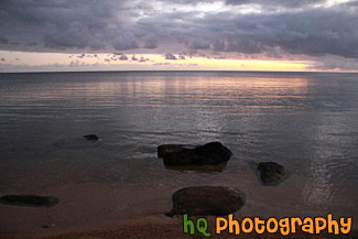
#1921 — A scenic coastal picture taken of the Pacific Ocean, waves, and rocks at Ruby Beach in Washington State.
Pacifc Ocean, Waves & Rocks
#2021 — A scenic picture taken of some seastacks and rocks located in the Pacific Ocean along the coast of Cannon Beach, Oregon. This picture was taken on a blue sky sunny day.
Seastacks & Rocks in Pacific Ocean
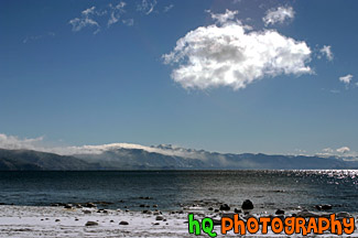
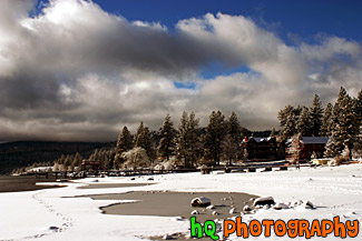
#285 — Beautiful scenic view of lake tahoe taken right after a snow storm. This photo is gorgeous because of the blue skies contrasting the freshly fallen snow covereing the shore and beach.
Beautiful Lake Tahoe Snow View
#195 — A pretty view at Lake Tahoe during July 2004. Lake Tahoe is the second deepest lake in the United States and the tenth deepest in the world, with a maximum depth measured at 1,645 ft (501 m), average depth of 1,000 ft (305 m). The Lake Tahoe Basin was formed by geologic block (normal) faulting about 2 to 3 million years ago. A geologic block fault is a fracture in the Earth's crust causing blocks of land to move up or down. Snow, rain, and streams filled the southern and lowest part of the basin, forming the ancestral Lake Tahoe. Modern Lake Tahoe was shaped and landscaped by the scouring glaciers during the Ice Age. Many streams flow into Lake Tahoe, but the lake is drained only by the Truckee River, which flows northeast through Reno and into Pyramid Lake in Nevada.
Lake Tahoe - Sand & Boats
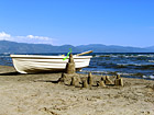
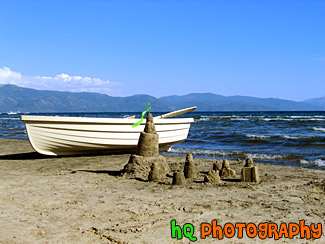
#197 — A pretty view at Lake Tahoe of a sand castle and boat during July 2004. Lake Tahoe is the second deepest lake in the United States and the tenth deepest in the world, with a maximum depth measured at 1,645 ft (501 m), average depth of 1,000 ft (305 m). The Lake Tahoe Basin was formed by geologic block (normal) faulting about 2 to 3 million years ago. A geologic block fault is a fracture in the Earth's crust causing blocks of land to move up or down. Snow, rain, and streams filled the southern and lowest part of the basin, forming the ancestral Lake Tahoe. Modern Lake Tahoe was shaped and landscaped by the scouring glaciers during the Ice Age. Many streams flow into Lake Tahoe, but the lake is drained only by the Truckee River, which flows northeast through Reno and into Pyramid Lake in Nevada
Lake Tahoe - Sand Castle & Boat
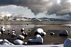
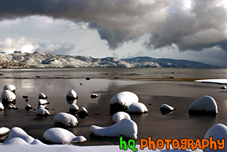
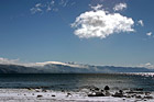
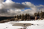
#284 — A scenic picture taken of Lake Tahoe right after a huge snow storm. Interesting and dramatic clouds are hovering in the skies above Lake Tahoe along with snow covering the rocks on the shore. On this particular day there was about a foot of snow that dropped down from the skies. A beautiful picture of what it is like in the winters at Lake Tahoe.
Lake Tahoe Clouds and Snow
#198 — A pretty view at Lake Tahoe during a November snow storm in 2004. The Lake Tahoe Basin was formed by geologic block (normal) faulting about 2 to 3 million years ago. A geologic block fault is a fracture in the Earth's crust causing blocks of land to move up or down. Snow, rain, and streams filled the southern and lowest part of the basin, forming the ancestral Lake Tahoe.
Lake Tahoe Snow, Clouds, & Beach
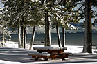
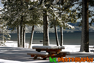
#286 — A pretty view of a snow covered picnic table at Lake Tahoe during a November snow storm. Lake Tahoe is the second deepest lake in the United States and the tenth deepest in the world, with a maximum depth measured at 1,645 ft (501 m), average depth of 1,000 ft (305 m).
Picnic Table & Lake Tahoe Snow
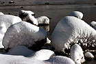
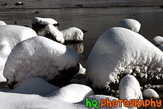
#283 — A scenic photo taken of rocks covered in snow right on the beach at Lake Tahoe. This photo was taken right after a huge snow storm at the end of November in 2004.
Snow Covered Rocks in Lake Tahoe
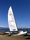
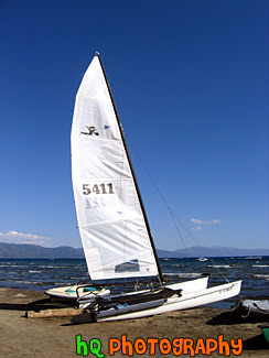
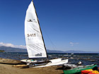
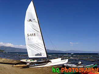
#196 — A pretty view at Lake Tahoe of a type of sail boat during July 2004. Lake Tahoe is the second deepest lake in the United States and the tenth deepest in the world, with a maximum depth measured at 1,645 ft (501 m), average depth of 1,000 ft (305 m). The Lake Tahoe Basin was formed by geologic block (normal) faulting about 2 to 3 million years ago. A geologic block fault is a fracture in the Earth's crust causing blocks of land to move up or down. Snow, rain, and streams filled the southern and lowest part of the basin, forming the ancestral Lake Tahoe. Modern Lake Tahoe was shaped and landscaped by the scouring glaciers during the Ice Age. Many streams flow into Lake Tahoe, but the lake is drained only by the Truckee River, which flows northeast through Reno and into Pyramid Lake in Nevada.
Lake Tahoe Sailboat
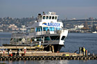
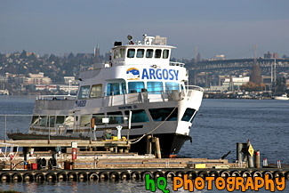
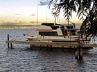
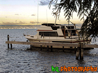
#857 — A scenic picture taken close up of a beautiful boat located in Seattle's Lake Union. This white boat has the word "Argosy" written on the front of the boat and is sitting close to the shore by the dock with a line of tires on the outside.
Boat in Seattle's Lake Union
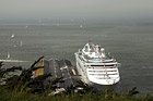
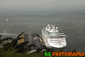
#802 — A scenic picture taken of a huge cruise ship located at the shore in the San Francisco Bay in California. In this picture you can also see many sailboats floating in the bay on this cloudy day.
Cruise Ship in San Francisco Bay
#14 — A photo of a boat waiting to be used in Lake Washington, Washington. Lake Washington is one of the biggest and most popular lakes in the Seattle, Washington area. This lake touches cities such as Kirkland, Shoreline, Seattle, Renton, New Castle, Bellevue, and Mercer Island. A lot of activities take place in this lake and is a joy amongst the residents of the state.
Lake Washington Boat
#206 — A pretty view at Lake Tahoe of a type of sail boat during July 2004. Lake Tahoe is the second deepest lake in the United States and the tenth deepest in the world, with a maximum depth measured at 1,645 ft (501 m), average depth of 1,000 ft (305 m). The Lake Tahoe Basin was formed by geologic block (normal) faulting about 2 to 3 million years ago. A geologic block fault is a fracture in the Earth's crust causing blocks of land to move up or down. Snow, rain, and streams filled the southern and lowest part of the basin, forming the ancestral Lake Tahoe. Modern Lake Tahoe was shaped and landscaped by the scouring glaciers during the Ice Age. Many streams flow into Lake Tahoe, but the lake is drained only by the Truckee River, which flows northeast through Reno and into Pyramid Lake in Nevada.
Sailboat & View of Lake Tahoe
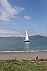
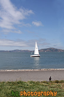
#2106 — A scenic vertical picture taken of a white sailboat floating in the San Francisco Bay Area waters with a black bird seen sitting on shore.
White Sailboat & Bird on Shore
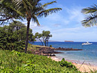
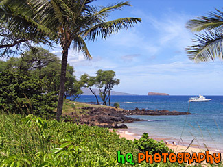
#207 — A scenic photo taken of a palm tree, boat, and the Pacific Ocean off the coast of Makena, Hawaii, which is on the island of Maui.
Beautiful Maui, Boat, and Pacific Ocean
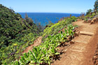
#2385 — A scenic picture taken of part of the Kalalau Trail located on the island of Kauai, Hawaii along the rugged Na Pali Coast.
Kalalau Trail on Na Pali Coast
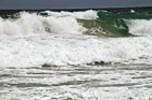
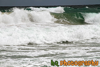
#2358 — A scenic picture taken close up of some big waves at Kealia Beach located in Kauai, Hawaii. Surfers and boogie boarders flock to this water for the regular surf and wild conditions due to the constantly changing sand bar. The half mile long beach is a favorite for jogging, dog walking, kite flying, and bon fires.
Kauai Waves at Kealia Beach
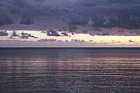
#2356 — A scenic beautiful picture taken of a Kauai, Hawaii sunrise with pink and purple skies reflected onto the Pacific Ocean. This photo was taken at Secret Beach near Princeville.
Kauai, Hawaii Sunrise
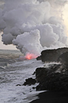
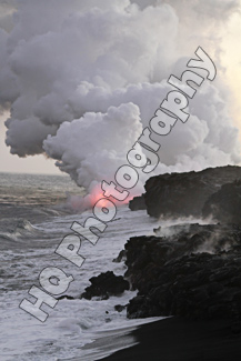
#2403 — A scenic vertical picture taken of lava entering the Pacific Ocean off the rocky coast of the Big Island, Hawaii.
Lava, Smoke, Rocky Shore
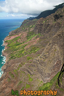
#2372 — A scenic vertical picture taken of the Na Pali Coast rugged cliffs located on the island of Kauai, Hawaii. This photo was taken in the air from aboard a helicopter.
Na Pali Coast
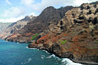
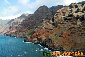
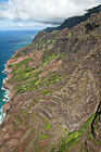
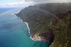
#2371 — A scenic aerial picture taken of the Na Pali Coast located on the island of Kauai, Hawaii. This photo was taken from a helicopter as this fifteen-mile stretch of rugged coastline on the northwest shore of Kauai is mostly inaccessible due to its characteristic sheer cliffs that drop straight down, thousands of feet into the ocean.
Na Pali Coast Cliffs
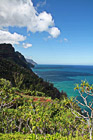
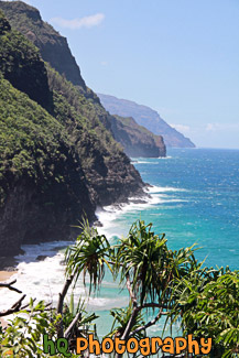
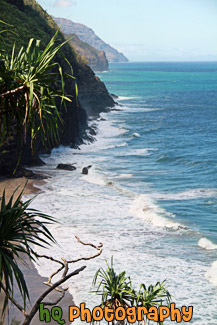
#2365 — A scenic vertical picture taken of the Na Pali coastline seen from hiking the Kalalau Trail in Kauai, Hawaii. Clouds and blue sky are seen above.
Na Pali Coast From Kalalau Trail
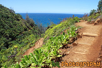
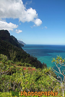
#2384 — A scenic vertical picture taken of the Na Pali Coast while hiking on the 11 mile long Kalalau Trail in Kauai, Hawaii.
Na Pali Coast on Kalalau Trail
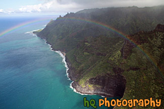
#2373 — A scenic picture taken of the Na Pali Coast of Kauai, Hawaii with a rainbow seen going across the picture. This photo was taken from the air in a helicopter.
Na Pali Coast Rainbow
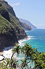
#2364 — A scenic picture taken of the Na Pali coastline located in Kauai, Hawaii from the ground. Blue waters and amazing cliffs are seen here.
Na Pali Coast, Kauai
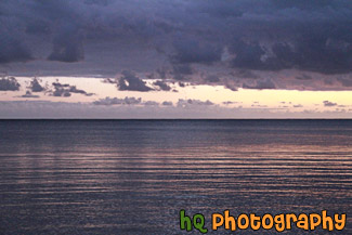
#2357 — A scenic picture taken of the sun rising at Secret Beach in Kauai, Hawaii near Princeville. In this photo you can see the pink and purple skies of the sunrise reflecting onto the Pacific Ocean. Rocks are also visible in the foreground.
Secret Beach, Kauai Surise
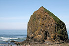
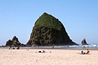
#2020 — A scenic picture taken of the popular Cannon Beach landmark, Haystack Rock. This photo was taken from a hill looking slightly down at the rock. You can see all of the people below observing Haystack Rock.
Haystack Rock From a Hill
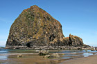
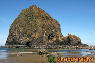
#2016 — A scenic picture taken of Haystack Rock which is located along the shore at Cannon Beach, Oregon. Haystack Rock is a popular tourist location in Oregon State.
Haystack Rock on Cannon Beach
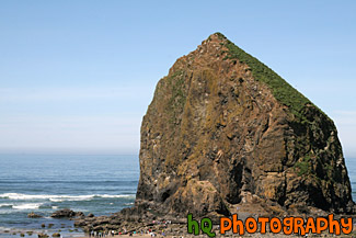
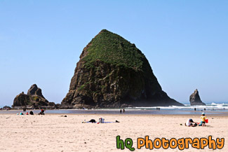
#1962 — A scenic picture taken of Haystack Rock located along the coastal shore in Cannon Beach, Oregon. Haystack Rock is a dedicated and protected Marine Garden. It rises 235 feet and is abundant with sea life. Haystack Rock is home to many birds such as tufted puffins, gulls, and cormorants.
Haystack Rock, Cannon Beach
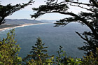
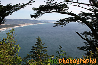
#2163 — A scenic picture taken of the scenic Oregon State coast and the Pacific Ocean from a top a hiking trail on a hill looking down at the ocean and shoreline. This photo was taken on a beautiful sunny day.
Oregon Coast Through Trees
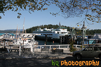
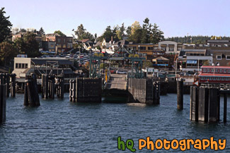
#2125 — A scenic picture taken of a ferry docking along the coast of Friday Harbor which is located on the San Juan Island in Washington State. This photo was taken on a sunny day.
Friday Harbor Ferry Docking
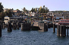
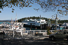
#2120 — A scenic picture pulling into the Friday Harbor ferry docking station which is located on the San Juan Islands in Washington State.
Friday Harbor Shore
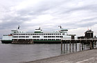
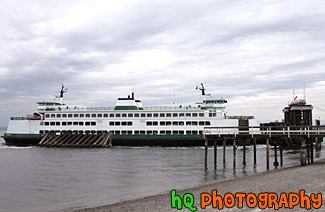
#1546 — A scenic picture taken of a Mukilteo ferry boat loading up cars at the shore.
Mukilteo Ferry
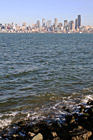
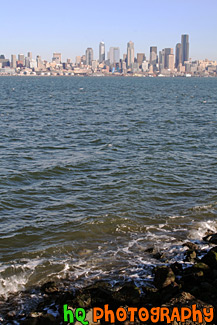
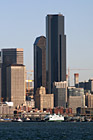
#1445 — A scenic vertical picture taken of the city of Seattle, the Puget Sound, waves and rocks from Alki Beach. This photo was taken on a sunny day.
Seattle & Alki Beach Rocks