Photos of Close Up Sun (46)
There are (46) photos of the keyword, Close Up Sun, available on our website. They are pictured below.The pictures are organized by category.


#1530 — A close up picture taken of the spiral rings of a calendar date book with sunlight shining on it.
Calendar Datebook
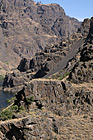
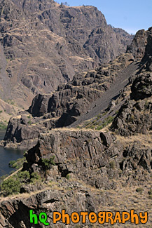
#2040 — A close up vertical picture of some rocks located at Hells Canyon National Recreation Area in northeastern Oregon and western Idaho.
Hells Canyon Rocks
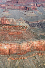
#2248 — A scenic vertical picture taken close up of the Grand Canyon at the South Rim of the National Park.
Grand Canyon Close Up at South Rim
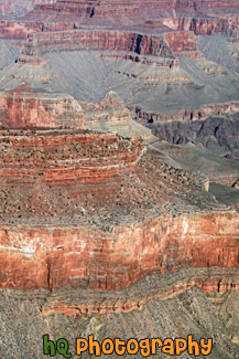
#2254 — A scenic close up picture taken of a wall of the grand canyon located on the south rim with blue sky seen above.
Grand Canyon Wall View
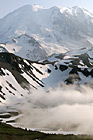
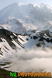
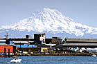
#1638 — A scenic vertical picture taken close up of Mt. Rainier with some fog seen at the base. This picture was taken at the Mount Fremont lookout located at the Sunrise entrance to the park.
Mt. Rainier & Fog
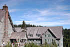
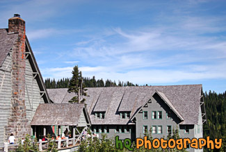
#1290 — A scenic picture taken of the Paradise Inn which is located near the base of Mount Rainier in the national park. Paradise Inn welcomes guests from mid-May to early October each year. Set against the spectacular backdrop of Mt. Rainier and the Nisqually Glacier, the inn is surrounded by glorious flowering meadows and scenic winding trails.
Paradise Inn Close Up
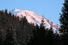
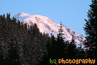
#1778 — A scenic picture taken of Mt. Rainier seen behind a hill during sunset as you can see a red tint on the mountain. This photo was taken at Lake Mowich near the Carbon River Entrance to the park.
Red Mt. Rainier
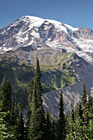
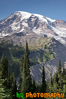
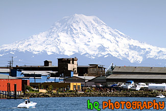
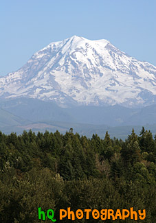
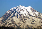
#1289 — A scenic vertical picture taken of Mt. Rainier close up on a beatiful sunny day.
Vertical Mt. Rainier Close Up
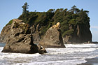
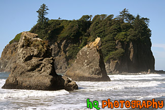
#1717 — A scenic picture taken of sea stacks located right off shore at Ruby Beach which is located in the Olympic National Park in Washington State. You can see a bird sitting on top of the second sea stack.
Ruby Beach Sea Stacks & Waves
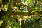
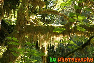
#1715 — A scenic close up picture taken of some light-green moss located on a tree in the Hoh Rain Forest which is in the Olympic National Park. The Hoh Rain Forest is one of the few temperate rain forests in the world, and is also one of the largest.
Hoh Rain Forest Moss
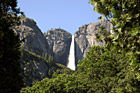
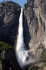
#788 — A close up picture taken of Yosemite Falls looking through green trees and blue sky in the background. Yosemite Falls is located in Yosemite National Park in California. Yosemite Falls is a waterfall actually composed of three falls: Upper, Middle Cascades, and the Lower fall. In this picture you can only see the Upper Falls. Together they have a combined height of 2,425 feet which is more than 9 times the height of Niagara Falls. Perhaps the easiest place to view the falls is the Yosemite Falls Parking Area across from Yosemite Lodge.
Yosemite Falls Through Trees

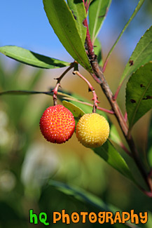
#1791 — A scenic vertical picture taken of a red and yellow berry located on a tree branch found on campus at the University of Washington in Washington State. This photo was taken on a sunny fall day.
Red & Yellow Berries on Tree
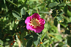
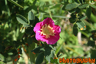
#2014 — A scenic close up photo taken of a pink flower with some sun rays and shadows on it.
Pink Flower in Sun & Shade

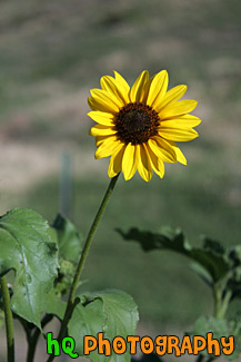
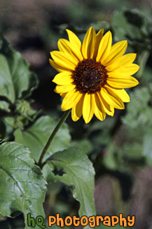
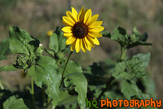
#2043 — A scenic close up vertical picture taken of a yellow sunflower located in western Idaho.
Sunflower


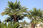
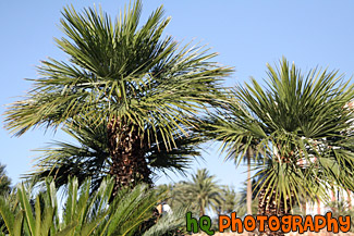
#1990 — A scenic picture taken of two palm trees close up with blue sky seen in the background.
Palm Trees & Blue Sky Up Close
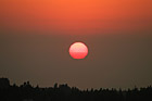
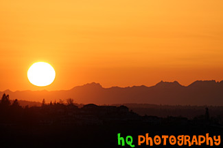
#1121 — A very interesting picture of a sunset close up taken in Washington State near Tacoma. The sky is lit up red and the sun has a red gradient to it.
Red Sun During Sunset
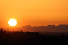
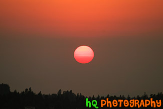
#1398 — A beautiful close up picture taken of a big orange sun settting over the Olympic Mountains located in Washington State. Ths sun is just about to go behind the mountains.
Sunset Over Olympics
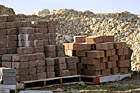
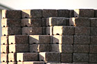
#968 — A close up scenic picture taken of some stacks of red bricks and rocks in the background. This picture was taken on a sunny day as you can see the blue sky in the distance and the shadows falling over the bricks.
Bricks and Rocks
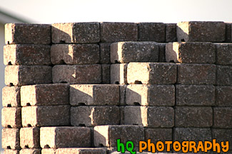
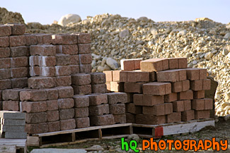
#940 — A scenic close up picture taken of a stack of red bricks with the sun and shadows shining on them. This photo was taken by a new house that was being built.
Stack of Bricks


#1532 — A close up picture taken of an orange sitting on a black table with sun light shining on it.
Orange


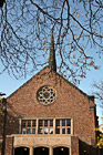
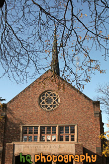
#1065 — A vertical picture taken close up of the Eastvold Chapel located on campus at Pacific Lutheran University in Tacoma, Washington. This photo was taken during the fall season as the trees are losing their leaves surrounding the chapel. Blue sky is seen above the chapel.
Pacific Lutheran University Eastvold Chapel
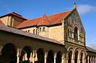
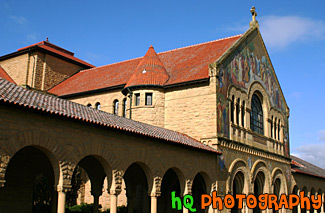
#800 — A beautiful picture taken of the side of Stanford Memorial church located on the Stanford University campus in California. This picture was taken on a sunny day with blue sky. Stanford Memorial Church stands at the center of the campus, and was one of the earliest and is still among the most prominent interdenominational churches in the West. Memorial Church is open to all religions and is non-denominational.
Side View of Stanford Memorial Church
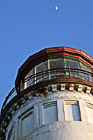
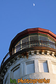
#2355 — A scenic close up vertical picture take of the North Head Lighthouse near Illwaco, Washington and Cape Disappointment, Washington. You can see the half-full moon in the sky beyond the lighthouse.
North Head Lighthouse & Moon
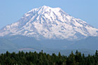
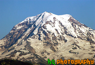
#574 — A close up picture taken of Mt. Rainier form the north side. This picture was taken on top of a hill in Bonney Lake, Washington near the Sky Island housing development area. On clear days, Mount Rainier dominates the Seattle - Tacoma skyline, towering over the metropolis in breathtaking beauty. Mount Rainiers highest elevation is 14,410 feet which is located at the summit.
Mt. Rainier North Side Close Up
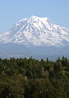
#749 — A close up vertical picture taken of Mt. Rainier form the north side. This picture was taken on top of a hill in Bonney Lake, Washington near the Sky Island housing development area. On clear days, Mount Rainier dominates the Seattle - Tacoma skyline, towering over the metropolis in breathtaking beauty. Mount Rainiers highest elevation is 14,410 feet which is located at the summit.
North Side of Mt. Rainier
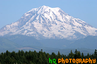
#909 — A close up scenic picture taken of the north side of Mount Rainier taken from a top a hill in Bonney Lake, Washington. Mount Rainier is one of the major symbols of Washington State and it is seen beautifully here on this sunny blue sky day.
North Side of Mt. Rainier Close Up
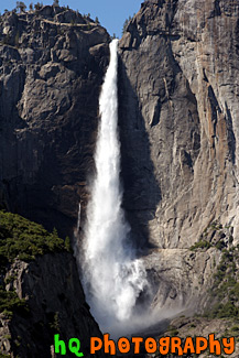
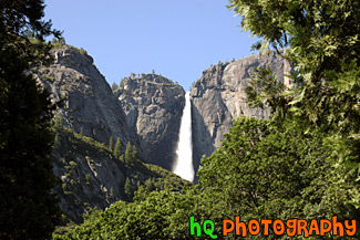
#620 — A close up picture taken of Yosemite Falls which is located in Yosemite National Park in California. Yosemite Falls is a waterfall actually composed of three falls: Upper, Middle Cascades, and the Lower fall. In this picture you can only see the Upper Falls. Together they have a combined height of 2,425 feet which is more than 9 times the height of Niagara Falls. Perhaps the easiest place to view the falls is the Yosemite Falls Parking Area across from Yosemite Lodge.
Yosemite Falls Close Up
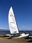
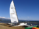
#196 — A pretty view at Lake Tahoe of a type of sail boat during July 2004. Lake Tahoe is the second deepest lake in the United States and the tenth deepest in the world, with a maximum depth measured at 1,645 ft (501 m), average depth of 1,000 ft (305 m). The Lake Tahoe Basin was formed by geologic block (normal) faulting about 2 to 3 million years ago. A geologic block fault is a fracture in the Earth's crust causing blocks of land to move up or down. Snow, rain, and streams filled the southern and lowest part of the basin, forming the ancestral Lake Tahoe. Modern Lake Tahoe was shaped and landscaped by the scouring glaciers during the Ice Age. Many streams flow into Lake Tahoe, but the lake is drained only by the Truckee River, which flows northeast through Reno and into Pyramid Lake in Nevada.
Lake Tahoe Sailboat
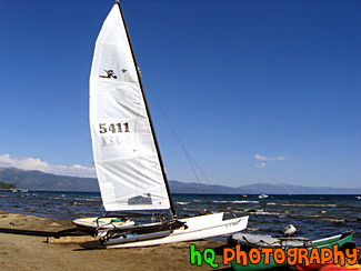
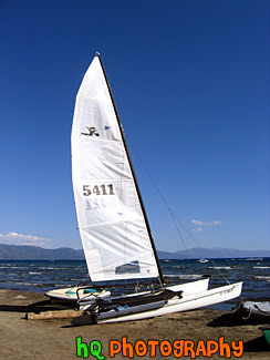
#206 — A pretty view at Lake Tahoe of a type of sail boat during July 2004. Lake Tahoe is the second deepest lake in the United States and the tenth deepest in the world, with a maximum depth measured at 1,645 ft (501 m), average depth of 1,000 ft (305 m). The Lake Tahoe Basin was formed by geologic block (normal) faulting about 2 to 3 million years ago. A geologic block fault is a fracture in the Earth's crust causing blocks of land to move up or down. Snow, rain, and streams filled the southern and lowest part of the basin, forming the ancestral Lake Tahoe. Modern Lake Tahoe was shaped and landscaped by the scouring glaciers during the Ice Age. Many streams flow into Lake Tahoe, but the lake is drained only by the Truckee River, which flows northeast through Reno and into Pyramid Lake in Nevada.
Sailboat & View of Lake Tahoe
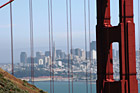
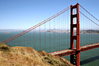
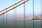
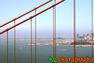
#402 — A scenic picture taken of the city of San Francisco, California looking through the Golden Gate Bridge. This picture was taken for the Marin County side of the bridge on a bright, sunny day in late spring. In the distance you can see the Bay Bridge, the Transamerica Pyramid, and the rest of the city. One of the best places to see the bridge is from the Marin Headlands, on the north side of the bridge. This shot was taken from a place called Battery Spencer in the Marin Headlands.
San Francisco View Through Golden Gate Bridge
#300 — This is a close up scenic photo of the arch of the Golden Gate Bridge just as the sun was about the set - as you can see from the changing colors in the sky. The Golden Gate Bridge is a historic symbol that represents the city of San Francisco. Joseph B. Strauss was the original chief engineer of the bridge and designed a rather unsightly cantilever and suspension structure in 1916. Though attempts were made to refine the design, it wasn't until consulting architects Irving F. Morrow and his wife Gertrude C. Morrow stepped in that the current look and design were imagined and implemented. The bridge opened for traffic 1937.
Arch of Golden Gate Bridge
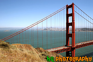
#587 — A scenic picture taken of the Golden Gate Bridge in California. In this picture you can see the city of San Francisco in the background and Alcatraz Island off to the left. This picture of the Golden Gate Bridge was taken from a place called Battery Spencer in the Marin Headlands.
Golden Gate Bridge from Battery Spencer

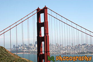
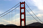
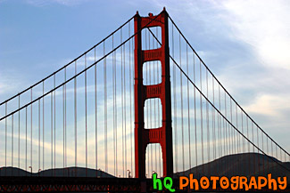
#2063 — A scenic picture taken of the Golden Gate Bridge located in San Francisco on a blue sky sunny day. This photo is taken of just one section of the bridge.
Golden Gate Bridge in San Franciso
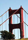
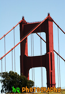
#591 — A scenic vertical picture taken of a close up of the tip of the famous Golden Gate Bridge located in San Francisco, California on a sunny blue sky day. The Golden Gate Bridge is a historic symbol that represents the city of San Francisco. If you look closely in this picture you can see two people standing on the hill just before the bridge. You can seen how tiny these people look in comparison to the great big bridge.
Tip of Golden Gate Bridge
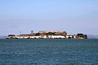
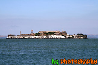
#1764 — A scenic picture taken of Alcatraz Prison and island on a sunny day in San Franciso, California. Alcatraz Island served as a military fortification in the 1850's, an incarceration facility for Spanish-American War prisoners, and a federal maximum-security prison from 1934 to 1963. Alcatraz Island is now one of Golden Gate National Recreation Area's most popular destinations.
Alcatraz Prison
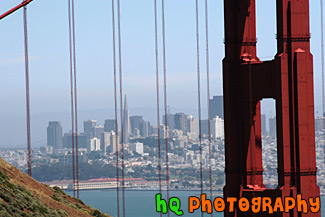
#774 — A scenic picture taken of the Bay Bridge in San Francisco, California while looking through the red bars of the Golden Gate Bridge. In this picture you can also see Coit Tower and the Transamerica Pryamid located in downtown San Francisco on this sunny day.
Bay Bridge seen through Golden Gate Bridge
#604 — A scenic picture taken of the Ghirardelli Square on a sunny day which is located in San Francisco, California. Ghirardelli Square is a historic San Francisco destination, offering shopping San Francisco style, waterfront dining near Fisherman's Wharf, art galleries, family events, walking tours and more. Today the original 1860 cast iron chocolate grinder from France is located on the lower plaza, and other chocolate-making equipment is still operating on a small scale in the Ghirardelli Chocolate Manufactory.
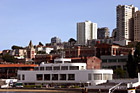
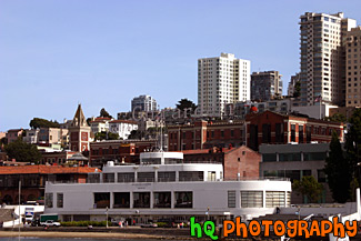
Ghirardelli Square
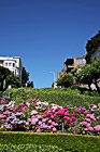
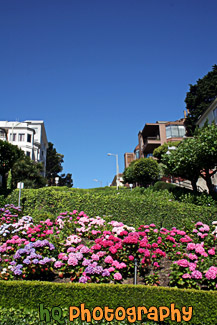
#681 — A close up picture taken of the flowers and curves of Lombard Street in downtown San Francisco, California. Lombard Street has eight sharp turns (or switchbacks) that have earned the street the distinction of being the most crooked (winding) street in the United States. One of San Francisco's car lines stops at the top of this block.
Lombard Street Close Up
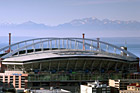
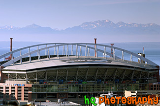
#817 — A close up picture taken of the Seattle Seahawk's Qwest Field with the snow capped Olympic Mountains and the sound in view in the background. This is the field in which the Seahawks play their home football games. Qwest Field has a 67,000 seat with over 70 percent of the roof being covered for the fans.
Olympic Mountains & Qwest Field
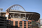
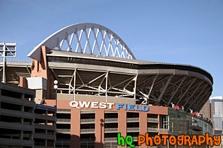
#1204 — A close up picture taken of Qwest Field located in downtown Seattle, Washington. Qwest Field is the baseball stadium in which the Seattle Mariners play their games. This photo was taken on a sunny day.
Qwest Field Up Close
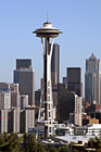
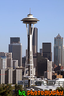
#123 — A view of the Space Needle located in Seattle, Washingon on this beautiful sunny day. The 605 foot (184 meter) Space Needle was designed by Edward E. Carlson for the 1962 World's Fair in Seattle. The Space Needle has become a symbol for the city, and is home to festive events such as the annual New Year's Eve fireworks display. The Space Needle was completed in December 1961, and officially opened four months later on the first day of the World's Fair, April 21, 1962.
Space Needle View
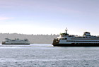
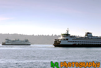
#821 — A close up scenic picture taken of two Seattle ferry boats in the Puget Sound. One ferry boat is leaving short while the other is on its way in. Washington State Ferries operates the largest ferry fleet in the United States. Twenty-eight ferries cross Puget Sound and its inland waterways, carrying over 26 million passengers to 20 different ports of call. From Tacoma, Washington, to Sidney, British Columbia, they travel up and down the Sound, acting as a marine highway for commercial users, tourists and daily commuters alike.
Two Seattle Ferry Boats