Home > Places > Mountains (Digital Paintings)
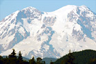
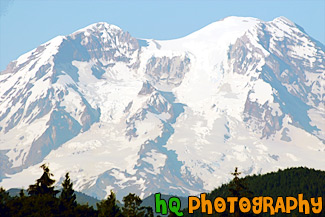
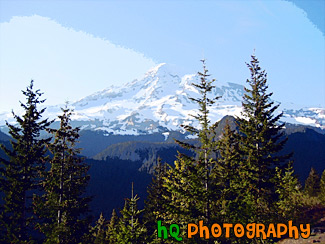
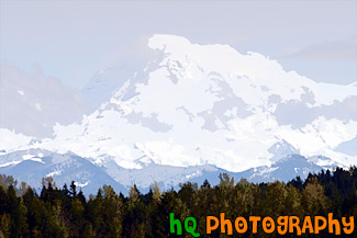
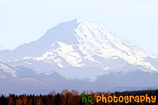
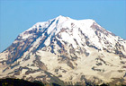
A close up picture taken of Mt. Rainier from the south-west side which is located in Washington State on a blue sky sunny day. "The Mountain", as it's known by natives, draws your eyes like a magnet when it is visible and not invisible behind clouds. It also draws over two million visitors each year. Mount Rainier and the surrounding foothills were designated as a national park in 1899. On clear days, Mount Rainier dominates the Seattle - Tacoma skyline, towering over the metropolis in breathtaking beauty. Mount Rainier's highest elevation is 14,410 feet which is located at the summit, also called Columbia Crest.
Image #534 | 3504 x 2336 pixels | 4.84 MB (jpg) | 23.4 MB (tif)
Close Up of Mt. Rainier
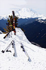
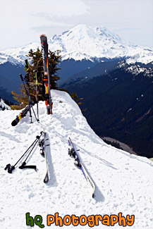
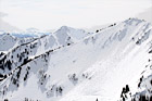
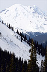
A scenic vertical picture taken of some skis stuck in the snow at the summit of Crystal Mountain with an amazing view of Mt. Rainier seen in the background.
Image #2236 | 2336 x 3504 pixels | 4.14 MB (jpg) | 23.4 MB (tif)
Mt. Rainier & Skis at Crystal Mountain Summit
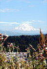
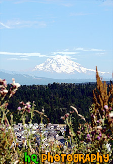
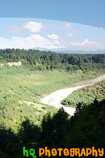
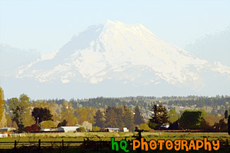
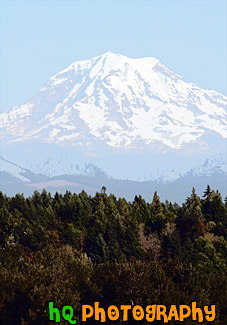
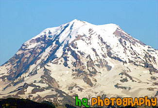
A scenic picture taken of the big Mt. Rainier located in Washington State. This picture was taken from Bonney Lake at the Sky Island housing development.
Image #525 | 2295 x 3343 pixels | 4.59 MB (jpg) | 22 MB (tif)
Mt. Rainier from Bonney Lake

A close up picture taken of Mt. Rainier form the north side. This picture was taken on top of a hill in Bonney Lake, Washington near the Sky Island housing development area. On clear days, Mount Rainier dominates the Seattle - Tacoma skyline, towering over the metropolis in breathtaking beauty. Mount Rainiers highest elevation is 14,410 feet which is located at the summit.
Image #574 | 3504 x 2336 pixels | 4.43 MB (jpg) | 23.4 MB (tif)
Mt. Rainier North Side Close Up
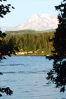
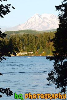
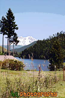
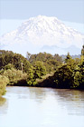
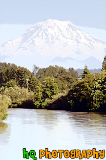
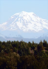
A scenic picture taken of Mt. Rainier through trees and with a lake in the foreground. Mt. Rainer is one of the most famous landmarks found in western Washington.
Image #550 | 2201 x 3287 pixels | 4.20 MB (jpg) | 20.7 MB (tif)
Mt. Rainier Through Trees & Lake
A beautiful picture of Mt. Rainier shot during the beginning of June. This photo was taken near Paradise in Mt. Rainier's National Forest. Blue sky and clouds are seen above the mountain in this photo.
Image #136 | 2592 x 1944 pixels | 2.53 MB (jpg) | 14.4 MB (tif)
Big Mt. Rainier
A beautiful picture of Mt. Rainier shot during the beginning of June. This photo was taken near Paradise in Mt. Rainier's National Forest. "The Mountain", as it's known by natives, draws your eyes like a magnet when it is visible and not invisible behind clouds. It also draws over two million visitors each year. Mount Rainier and the surrounding foothills were designated as a national park in 1899. On clear days, Mount Rainier dominates the Seattle - Tacoma skyline, towering over the metropolis in breathtaking beauty. Mount Rainiers highest elevation is 14,410 feet which is located at the summit, also called Columbia Crest. The glaciers on Mount Rainier are the sources of five major river systems: Nisqually, Cowlitz, White, Carbon, and Puyallup. These rivers provide water for plants, animals, and humans throughout western Washington.
Image #164 | 2592 x 1944 pixels | 3.47 MB (jpg) | 14.4 MB (tif)
Blue Sky & Mt. Rainier
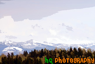
A scenic picture taken of the Cascade Foothills located in Washington State near Mt. Rainier. In this photo you can see snow on the foothills, green evergreen trees in the foreground and some low clouds hovering over the mountains.
Image #1029 | 3504 x 2336 pixels | 3.02 MB (jpg) | 23.4 MB (tif)
Cascade Foothills & Clouds
A scenic picture taken of a view of the Cascade Mountains looking from Mud Mountain Dam. The Cascades are filled with many evergreen trees as you can see in the picture. This photo was taken on a partly cloudy and sunny day in Washington State.
Image #945 | 2336 x 3504 pixels | 4.94 MB (jpg) | 23.4 MB (tif)
Cascade Mountains
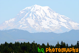
A scenic picture taken of Mount Rainier on a partly cloudy day as you can see the blue sky above the mountain and clouds hovering around it. This picture was taken looking toward the north side of Mount Rainier from Bonney Lake, Washington.
Image #1028 | 3504 x 2336 pixels | 3.56 MB (jpg) | 23.4 MB (tif)
Clouds, Blue Sky & Mt. Rainier
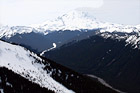
A scenic picture taken at Crystal Mountain Summit, Washington during the winter season. In the background you can see Mt. Adams.
Image #2329 | 3504 x 2336 pixels | 4.28 MB (jpg) | 23.4 MB (tif)
Crystal Moutntain View of Mt. Adams
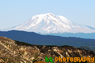
A scenic picture taken of Mount Adams seen from Mount St. Helens which is located in Washington State. Mount Adams is a stratovolcano located in the Cascade Range and the second highest mountain in the Pacific Northwest of the United States. Its' summit is 12,276 feet in elevation. Adams is located in a remote wilderness approximately 35 miles east of Mount St. Helens.
Image #662 | 3504 x 2336 pixels | 4.55 MB (jpg) | 23.4 MB (tif)
Mount Adams, Washington
A beautiful scenic picture taken of the north side of Mount Rainier on a blue sky sunny day during the winter season. You can see all the snow covering the mountain. Mount Rainier is located in Washington state and this photo was taken from a hill in Bonney Lake.
Image #938 | 3504 x 2336 pixels | 3.84 MB (jpg) | 23.4 MB (tif)
Mount Rainier in During Winter Season
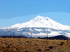
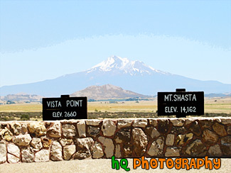
Mt. Shasta located in Northern California on the Cascade Range. Mount Shasta stands 14,162 feet high. Avalanche Gulch route is one of the most popular and climbed routes in the United States with an estimated 15,000 climbers that attempt the summit annually. With 17 established routes, each with variations, there is climbing available for beginners as well as advanced mountaineers. The terrain consists of loose volcanic talus, rock & ice, and glaciers. This photo was taken on a sunny day.
Image #66 | 1600 x 1200 pixels | 1.17 MB (jpg) | 5.49 MB (tif)
Mount Shasta
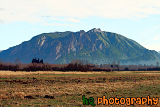
A scenic picture taken of Mount Si which is located in North Bend, Washington State. Mount Si is a popular hike for a lot of hikers in Washington. The climb is 4,167 feet (1,270 meters) and 4 miles from the parking lot to the summit plateau. Vertical elevation change is about 3700 feet and starts at about 700 feet. The route meanders through several different ecosystems as temperatures and average rainfall vary with elevation.
Image #1935 | 3504 x 2336 pixels | 5.10 MB (jpg) | 23.4 MB (tif)
Mount Si
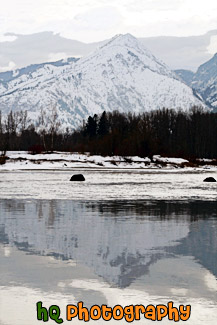
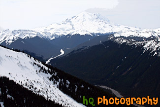
A scenic vertical photo taken of the Cascade Mountain Range located near Stevens Pass and Leavenworth and a snowy winter day. The reflection of the mountain range can be seen in the lake in the foreground.
Image #2160 | 2336 x 3504 pixels | 6.00 MB (jpg) | 23.4 MB (tif)
Mountain Reflection & Snow
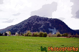
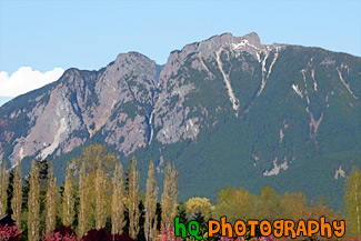
A scenic picture taken of the local small mountain in which people of the area hike up to receive and excellent workout. This picture was taken on a cloudy day in Enumclaw, Washington. A green grass field is seen in the foreground and a little bit of smoke is seen just before the mountain.
Image #1008 | 3504 x 2336 pixels | 4.05 MB (jpg) | 23.4 MB (tif)
Mt. Peak, Enumclaw
A scenic picture taken of Mt. Rainer on a clear, blue sky. This photo was taken in the farmland in Enumclaw, Washington where the mountain looks big.
Image #1759 | 3504 x 2336 pixels | 5.22 MB (jpg) | 23.4 MB (tif)
Mt. Rainer & Farmland
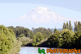
A scenic picture taken of Mt. Rainier with the Puyallup River in the foreground. This photo was taken on a beautiful sunny day with blue skies in Washington State.
Image #1101 | 3504 x 2336 pixels | 5.02 MB (jpg) | 23.4 MB (tif)
Mt. Rainier & Puyallup River
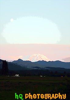
A scenic picture of Mt. Rainier taken at sunset with a full moon in the sky. This picture was taken in Enumclaw, Washington. Mount Rainier dominates the Seattle - Tacoma skyline, towering over the metropolis in breathtaking beauty. Mount Rainiers highest elevation is 14,410 feet which is located at the summit, also called Columbia Crest.
Image #417 | 2336 x 3316 pixels | 3.13 MB (jpg) | 23.4 MB (tif)
Mt. Rainier at Sunset & Full Moon
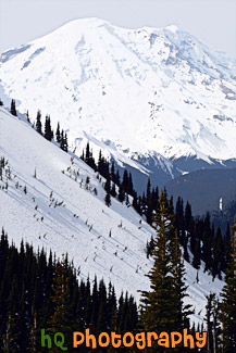
A scenic vertical picture taken of Mt. Rainier from the top of Crystal Mountain in Washington State. This photo was taken from the Powder Pass Run that leads down to the Lucky Shot from the Rainier Express lift. Mt. Rainier is seen with snow piled on.
Image #2237 | 2336 x 3504 pixels | 4.47 MB (jpg) | 23.4 MB (tif)
Mt. Rainier Close Up at Top of Crystal Mountain
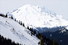
A scenic picture taken of Mt. Rainier covered with snow from Powder Pass on Crystal Mountain in Washington State.
Image #2264 | 3504 x 2336 pixels | 4.44 MB (jpg) | 23.4 MB (tif)
Mt. Rainier From Crystal Mountain
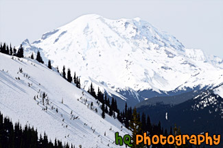
A scenic picture taken of Mt. Rainier from the Crystal Mountain Summit. At the top of Crystal Mountain in Washington State, you get an amazing view of Mt. Rainier (when it is not hiding behind clouds).
Image #2235 | 3504 x 2336 pixels | 3.94 MB (jpg) | 3.94 MB (tif)
Mt. Rainier From Crystal Mountain Summit
A scenic picture taken of Mt. Rainier in the distance, a lake in the middle and a grass field/fence in the foreground.
Image #1285 | 2336 x 3504 pixels | 5.44 MB (jpg) | 23.4 MB (tif)
Mt. Rainier in Distance

A scenic picture taken of Mt. Rainier from Tacoma, Washington. In this picture it looks like Mt. Rainier is floating on clouds below it.
Image #1342 | 3504 x 2336 pixels | 3.95 MB (jpg) | 23.4 MB (tif)
Mt. Rainier View at Tacoma
A scenic vertical picture taken of Mt. Rainier in Washington State with the Puyallup River in the foreground.
Image #1102 | 2336 x 3504 pixels | 4.80 MB (jpg) | 23.4 MB (tif)
Mt. Rainier, Blue Sky & Puyallup River
A scenic picture taken of Mt. Rainier on a beautiful blue sky, sunny day in Washington State. This photo was taken from the Sky Island housing development area in Bonney Lake.
Image #1055 | 3504 x 2336 pixels | 4.23 MB (jpg) | 23.4 MB (tif)
Mt. Rainier, Blue Sky & Scattered Clouds
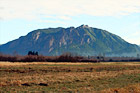
Mt. Shasta located in Northern California on the Cascade Range. Mount Shasta stands 14,162 feet high. Avalanche Gulch route is one of the most popular and climbed routes in the United States with an estimated 15,000 climbers that attempt the summit annually. With 17 established routes, each with variations, there is climbing available for beginners as well as advanced mountaineers. The terrain consists of loose volcanic talus, rock & ice, and glaciers.
Image #65 | 1600 x 1200 pixels | 1.30 MB (jpg) | 5.49 MB (tif)
Mt. Shasta
A scenic picture of the popular Mount Si located in North Bend, Washington. Mount Si is a popular hike that many locals take. This photo was taken on a sunny winter afternoon.
Image #2178 | 3504 x 2336 pixels | 5.59 MB (jpg) | 23.4 MB (tif)
Mt. Si in North Bend
A close up vertical picture taken of Mt. Rainier form the north side. This picture was taken on top of a hill in Bonney Lake, Washington near the Sky Island housing development area. On clear days, Mount Rainier dominates the Seattle - Tacoma skyline, towering over the metropolis in breathtaking beauty. Mount Rainiers highest elevation is 14,410 feet which is located at the summit.
Image #749 | 2336 x 3344 pixels | 4.04 MB (jpg) | 22.3 MB (tif)
North Side of Mt. Rainier
A close up scenic picture taken of the north side of Mount Rainier taken from a top a hill in Bonney Lake, Washington. Mount Rainier is one of the major symbols of Washington State and it is seen beautifully here on this sunny blue sky day.
Image #909 | 3321 x 2274 pixels | 7.60 MB (jpg) | 21.6 MB (tif)
North Side of Mt. Rainier Close Up
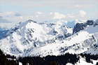
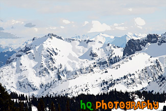
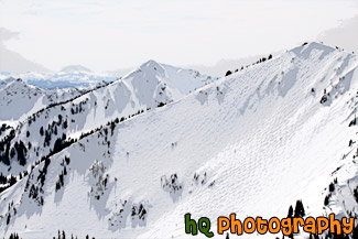
A scenic picture taken of snowy mountain tops located in Mt. Rainier National Park in Washington State. This picture was taken on a partly cloudy day.
Image #1823 | 3504 x 2336 pixels | 4.29 MB (jpg) | 23.4 MB (tif)
Snowy Mountain Tops
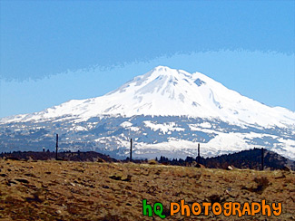
A view of Mt. Shasta, Ca. Mt. Shasta located in Northern California on the Cascade Range. Mount Shasta stands 14,162 feet high. Avalanche Gulch route is one of the most popular and climbed routes in the United States with an estimated 15,000 climbers that attempt the summit annually. With 17 established routes, each with variations, there is climbing available for beginners as well as advanced mountaineers. The terrain consists of loose volcanic talus, rock & ice, and glaciers.
Image #192 | 2592 x 1944 pixels | 2.92 MB (jpg) | 14.4 MB (tif)
View of Mt. Shasta
