San Francisco View from Mt. Tamalpais Art Painting

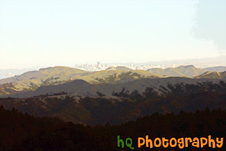
A scenic picture taken of the city of San Francisco from a distance at Mt. Tamalpais State Park in Marin County. From this picture you can see the tops of the tall buildings in San Franicso cover the green hills as well as the very tip of the Golden Gate Bridge. Alcatraz and the Bay Bridge is also visible in this photo. Mt. Tamalpais is located just north of San Francisco's Golden Gate and is 6,300 acres of redwood groves and oak woodlands with a spectacular view from the 2,571-foot peak (which is where this was taken). With the Gold Rush of 1849, San Francisco grew and more people began to use Mount Tamalpais for recreation. Trails were developed and a wagon road was built.
Related Photos
mount tamalpais, san francisco from mt tamalpais, spectacular view from mt tamalpais marin county, san francisco taken from mount tamalpais, golden gate bridge from mt tamalpais, bay area from mount tamalpais, marin county at mount tamalpais
Related Photos
mount tamalpais, san francisco from mt tamalpais, spectacular view from mt tamalpais marin county, san francisco taken from mount tamalpais, golden gate bridge from mt tamalpais, bay area from mount tamalpais, marin county at mount tamalpais
Camera Settings (EXIF Data)
- Shutter Speed: 1/250 seconds
- Lens Aperture: F/14
- Focal Length: 80 mm
- Image Resolution: 3072 x 2048 pixels
- Image Size: 2.98 MB (JPG), 18 MB (TIF)
- Date Photo Taken: April 10, 2005 4:59 PM
- File Name: 433_mt_tamalpais.jpg
- Image ID: # 433
- Date added to website: 27-Jun-2005
Even more stuff
- Large Poster Format
- Request an image
- Free wallpaper collection
- Return Policy
- Questions? Contact HQ Photography.
