Photos of Tire (17)
There are (17) photos of the keyword, Tire, available on our website. They are pictured below.The pictures are organized by category.


#1259 — A close up picture taken of a golden retriever panting and looking at the camera. This lab has been playing in a dog park.
Golden Retriever Panting
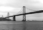
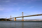
#332 — This is a scenic black and white picture taken of the Bay Bridge in San Francisco, California which connects San Francisco to Oakland. This photo was taken on a cloudy day and you can see the details of the clouds in the photo. This photo is taken from the San Francisco side looking towards Treasure Island.
Black & White Bay Bridge & Clouds


#701 — A close up picture taken of four yellow #2 pencils and a red colored pencil in the middle on a white background.
Pencils

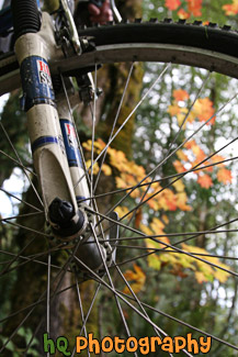
#2131 — A scenic vertical picture taken close up of a mountain bike tire with the fall colors of trees in the background.
Mountain Bike Tire
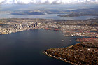
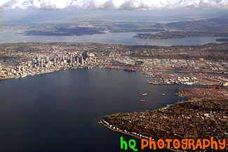
#258 — This is an aerial view of Seattle, Washington taken from an airplane flying into the SeaTac Airport. From this photo you can see the city of Seattle, the tall buildings, the Space Needle, and the bay and water. You can also see the Seahawks and the Mariner's stadiums. From this photo you can actually see it ALL! You can see I90, 520, Lake Washington, and Lake Sammamish in the far distance!
Aerial View of Seattle, Washington

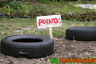
#1595 — A scenic picture taken of the potato's sign located at the Green Gulch Farm in Marin County, California.
Potatos at Green Gulch Farm
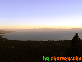
#205 — A pretty view at Lake Tahoe during July 2004. Lake Tahoe is the second deepest lake in the United States and the tenth deepest in the world, with a maximum depth measured at 1,645 ft (501 m), average depth of 1,000 ft (305 m). The Lake Tahoe Basin was formed by geologic block (normal) faulting about 2 to 3 million years ago. A geologic block fault is a fracture in the Earth's crust causing blocks of land to move up or down. Snow, rain, and streams filled the southern and lowest part of the basin, forming the ancestral Lake Tahoe. Modern Lake Tahoe was shaped and landscaped by the scouring glaciers during the Ice Age. Many streams flow into Lake Tahoe, but the lake is drained only by the Truckee River, which flows northeast through Reno and into Pyramid Lake in Nevada.
Overall View of Lake Tahoe
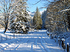
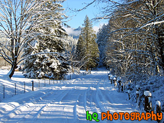
#29 — A beautiful winter scene picture taken when Washington state had a blast of cold weather and snow. This photo was taken in the foothills of the Cascade Mountains in Enumclaw, Washington. In this picture you can see a snow covered driveway with shadows from the sun shining over it. The trees surrounding the driveway are covered in snow.
Beautiful Winter Snow Scene
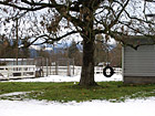
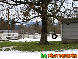
#43 — A photo of a tire swing with snow on the ground during the winter season. This photo was taken in Washington State.
Tire Swing & Snow

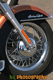
#2059 — A close up vertical picture taken of a Harley Davidson motorcycle tire.
Harley Davidson Motorcycle Tire
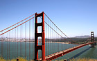
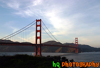
#578 — A scenic wide angle view of the Golden Gate Bridge taken from the Marin County side of the bridge. In this picture you can see the start of the Pacific Ocean off the the right and the city of San Francisco, California off to the left. The Golden Gate bridge is arguably one of the world's most beautiful bridges as the Golden Gate Bridge is an internationally recognized symbol of San Francisco.
Golden Gate Bridge
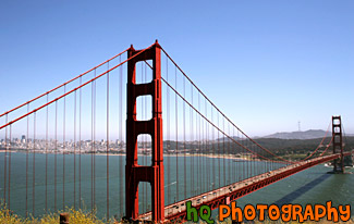
#298 — A scenic photo of the Golden Gate Bridge taken from the San Fancisco side of the bridge. This photograph is taken of the entire bridge a little bit before sunset as you can see the sky start to change colors. The Golden Gate bridge is arguably one of the world's most beautiful bridges as the Golden Gate Bridge is an internationally recognized symbol of San Francisco.
Golden Gate Bridge Facts: Joseph B. Strauss was the original chief engineer of the bridge and designed a rather unsightly cantilever and suspension structure in 1916. Though attempts were made to refine the design, it wasn't until consulting architects Irving F. Morrow and his wife Gertrude C. Morrow stepped in that the current look and design were imagined and implemented. The bridge opened for traffic 1937.
Golden Gate Bridge View
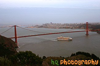
#363 — A scenic picture taken of the entire Golden Gate Bridge in San Francisco with a view of the city behind and a big cruise ship leaving the bay area underneath. This picture was taken at dusk from the top of Hawk Hill which is located just north of San Francisco in the Marin Headlands.
Cruise Ship Under Golden Gate Bridge
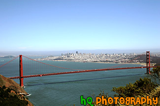
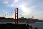
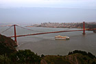
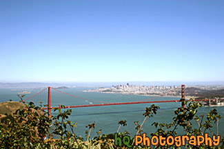
#580 — A scenic picture taken of the entire Golden Gate Bridge from Hawk Hill near San Francisco. Hawk Hill is located just north of San Francisco, California in the Marin Headlands. From this position you are actually above the Golden Gate Bridge looking down at it and the city.
Entire Golden Gate Bridge View
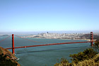
#581 — A scenic picture taken of the Golden Gate Bridge with some green shrubs in the foreground. In this picture you can see the entire view of the Golden Gate Bridge along with the city of San Francisco in the background and Alcatraz Island off to the left. This picture was taken from Hawk Hill which is located just north of San Francisco in the Marin Headlands.
Golden Gate Bridge from Hawk Hill
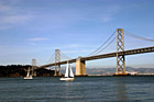
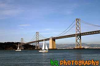
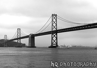
#565 — A full view picture taken of the Bay Bridge and some sailboats sailing by on a sunny day in San Francisco, California. The bay bridge connects the city of San Francisco with the city of Oakland.
Full View of Bay Bridge & Sailboats
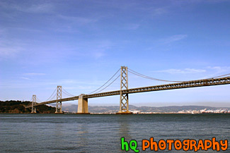
#784 — A scenic picture taken of the entire San Francisco - Oakland Bay Bridge located in San Francisco, California. This picture was taken on a sunny day in the spring season. The Bay Bridge opened to traffic on November 12, 1936. Its total cost, including an electric railroad which has since been abandoned, was $79.5 million. The best ways to enjoy the Bay Bridge are: From the San Francisco waterfont along Embarcadero Street, where you can see and photograph the span, and walk under it.
San Francisco Bay Bridge & Blue Sky
